QUICK LINKS
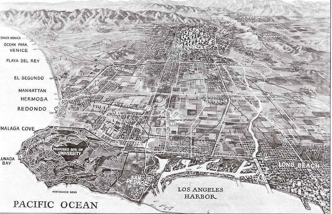
History of the South Bay of Los Angeles Through 1900
Palos Verdes Secrets and Little Known Facts
History of Palos Verdes Estates
History of Rancho Palos Verdes
History of Rolling Hills Estates and Rolling Hills
History of Manhattan Beach
History of Hermosa Beach
History of Redondo Beach
History of El Segundo
History of San Pedro
History of Torrance
History of Lomita
Seaview Landslide Information
History of Rancho Palos Verdes
BY BRUCE AND MAUREEN MEGOWAN
Rancho Palos Verdes History has an amazing story to tell of a City founded to protect the natural beauty of the Palos Verdes Peninsula.
Frank Vanderlip Acquisition
Early in 1913, George Bixby decided to sell approx. 16,000 acres of the Rancho de los Palos Verdes (retaining about 1,000 acres which later became Harbor City), which his father, Jotham Bixby, had acquired in 1882 by a legal partition of the original land grant area of Rancho de los Palos Verdes (See The History of the South Bay for a discussion of the early Indian inhabitants of the Palos Verdes Peninsula and the early Spanish land grant Ranchos). The sale of Rancho de los Palos Verdes then became an incredibly complex series of real estate transactions, options and litigation.
Bixby initially granted, for $25,000, an option to buy the property to millionaires W.I. Hollinsworth and D.O. Miller for a reported $1.5 million . When they could not perform, Mr. Walter Fundenburg, paid an additional $175,000 to Bixby for the option to acquire the property for approx. $1.8 million, $800,000 in cash and the balance in one year (Most historical accounts state that the purchase price was $1,500,000, with $600,000 in cash and the rest in notes, however an article in 1914 quotes the broker on the transaction, Mr. Carl F. Schader as stating that the transaction was for approx. $1.8 million, not $1.5 million).
Mr. Schader agreed to purchase approx. 2,000 acres of coastline from Mr. Fundenburg for approx. $500,000 if Fundenberg were successful in execising his option to buy the entire 16,000 acres and paid Mr. Bixby an additional $36,000 in fees. Mr. Edward L. Doheny then paid the Bixby’s an additional $25,000 relating to the option of Mr. Fundenberg. Mr. Doheny then backed out of the deal, forfeiting his option money. After much litigation, Bixby agreed to allow Schader and Adams 60 days to complete the purchase of the entire 16,000 acres by Mr. Fundenberg. Mr. Schader initially tried to raise the funds from San Francisco investors, then left for New York to raise the money, with about 17 days left to raise the funds, and while there was able to get Mr. Frank A. Vanderlip, then President of the City National Bank of New York, interested in the property. Although Mr. Vanderlip had never seen the property, after only a 10 minute meeting with Mr. Schader, he was intrigued and recognized its potential for development.
By November 1913, Mr. Vanderlip organized a consortium of New York investors and completed the purchase of the property. An LA Times article in 1914 stated that the Vanderlip consortium paid $741,184 in cash and $1,000,000 in notes ( which included a $150,000 second mortgage to Fundenberg). In the end, Bixby received over $1.8 million in option fees ($236,000) and cash and notes ($1,591,184) for the sale of the Palos Verdes Peninsula.
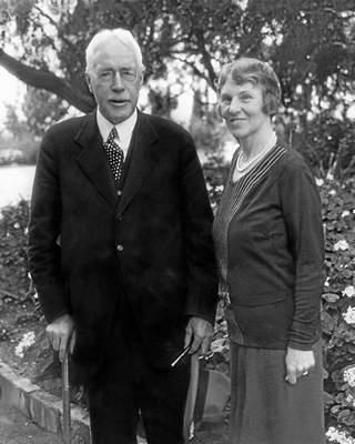
Initially, Vanderlip’s investors intended to divide the land into large estates. The founding father of the Peninsula, Frank Vanderlip, was one of these investors. Vanderlip was a self-made man, an Assistant Secretary of the Treasury under President McKinley, president of the National City Bank of New York, and socially connected to prominent Eastern financiers, civic, educational, and political figures. The syndicate Vanderlip formed to finance the purchase of the Palos Verdes Ranch consisted of over fifty wealthy men including Harry P. Davidson of J. P. Morgan and Company; Benjamin Strong, president of the Bankers’ Trust Company of New York; and Frank Trumbull, chairman of the board of the Chesapeake and Ohio Railroad.
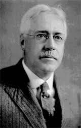
Mr. Frank Vanderlip
From the beginning, Vanderlip had great plans for the development of the property. As early as 1914, Vanderlip hired architects, including the landscape architectural firm of Olmsted Brothers, to draw up a masterplan for the development. Original plans included the construction of a magnificent golf club on the bluffs overlooking Portuguese Bend, to be known as “Los Palos Verdes Country Club”. The golf links was to include a clubhouse with 150 guest rooms, locker rooms,and numerous dining and community rooms. Other amenities were to include a large swimming pool, tennis courts, polo grounds, and a yacht club with concrete pier.
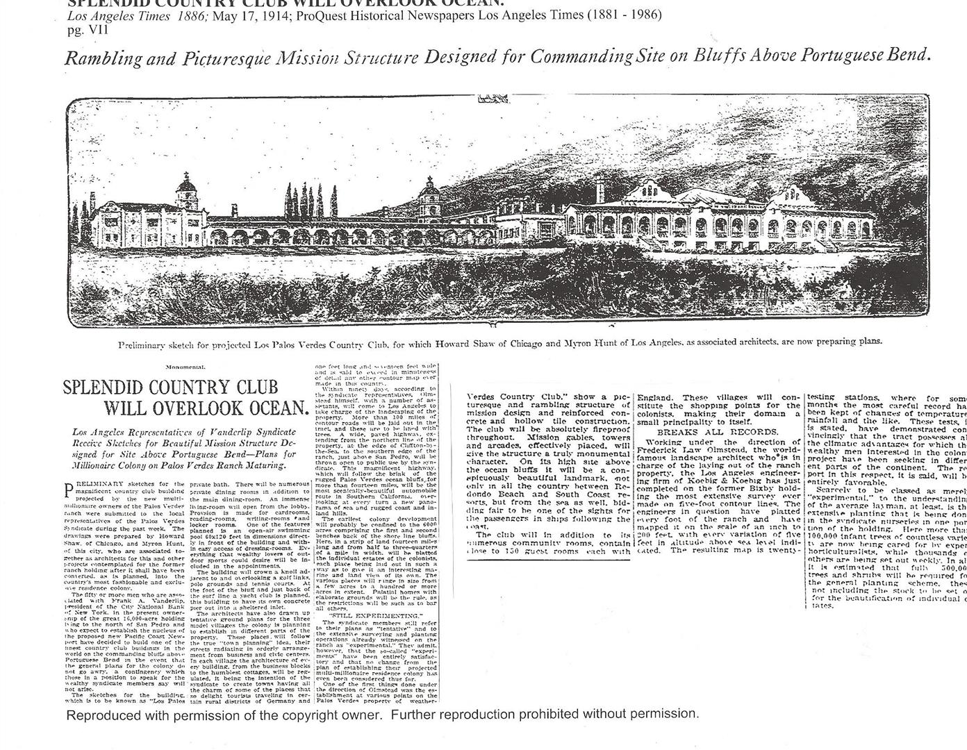
Article published on 5/17/1914 in the Los Angeles Times about the proposed Los Palos Verdes Country Club in the Portuguese Bend Club area
His initial plans for the development, however, were interrupted by World War I. The Olmsted Brothers were known to Vanderlip since they were the landscape architects, beginning in 1913, for Beechwood, his 147 acre estate at Scarborough-on-the-Hudson, New York. It appears that the syndicate had little input into the development of the Palos Verdes Ranch project. Rather, it was Vanderlip who suggested to Olmsted Brothers the direction for its design program, and the landscape architecture firm took the lead, apparently with the full confidence of the syndicate.
Vanderlip writes glowingly in his biography about a visit in 1916 to the Palos Verdes Peninsula and the property he bought unseen three years earlier. He describes his vision for the development, likening the geographical location to Italy where he took vacations:
“I found myself reminded vividly of the Sorrentine Peninsula and the AmalfiDrive: Yet the most exciting part of my vision was that this gorgeous scene was not a piece of Italy at all but was here in America, an unspoiled sheet of paper to be written on with loving care.”
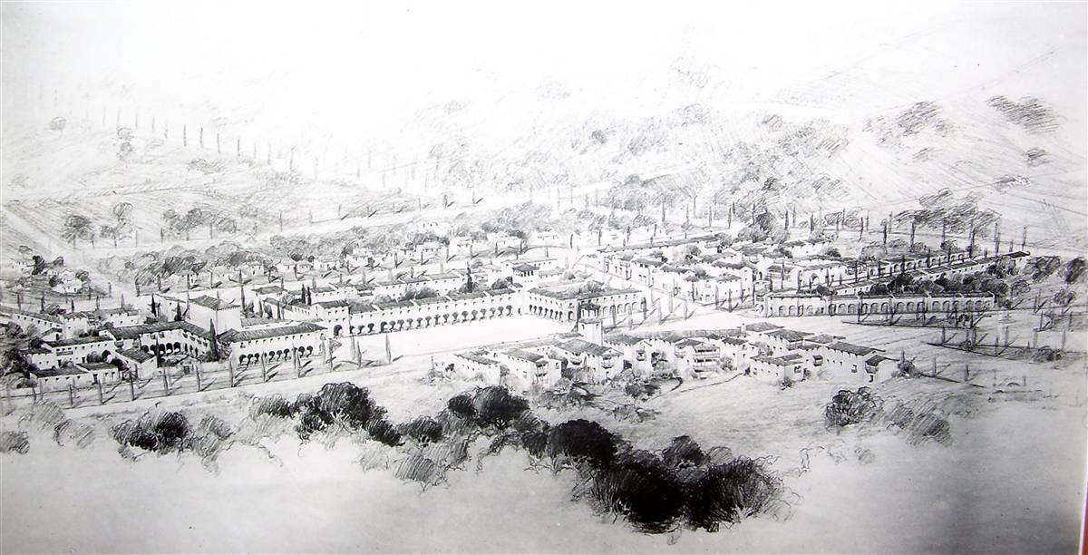
Vanderlip planned to develop the area above the current Point Vicente lighthouse including the present day Golden Cove Shopping Center and the Rancho Palos Verdes City Hall area as an Italian hillside village, to be occupied by craftsmen who would live, work, and sell their wares. In 1916, Congress approved funding to build the lighthouse at Point Vicente. Since this was land that Vanderlip had master-planned as an artisan community modeled after the Italian village Neri, he fought the government for 5 years, however the Federal government finally acquired the 8 acre site and constructed the lighthouse which went into service in 1926. Marble was imported from Italy for the first building of the Village in 1928, but due to the start of the Great Depression, the project was never completed.
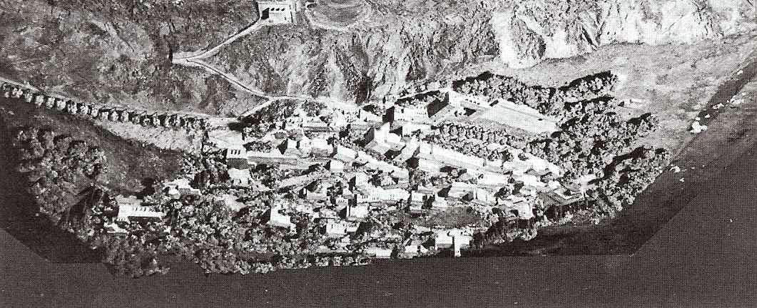
Model of original Frank Vanderlip proposed artisan village at the current site of the Point Vicente Lighthouse and the Terranea Resort.
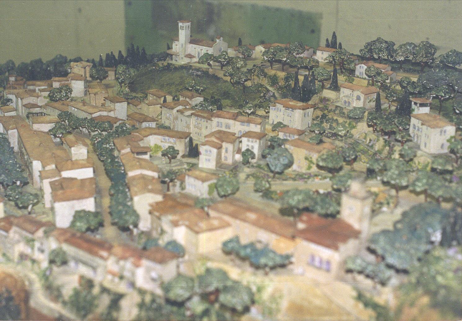
Close-up of Model of original Frank Vanderlip proposed artisan village
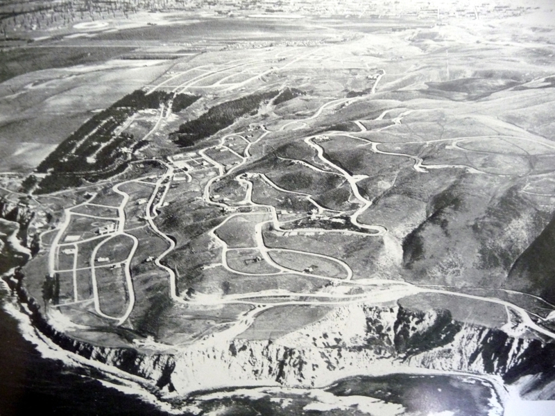
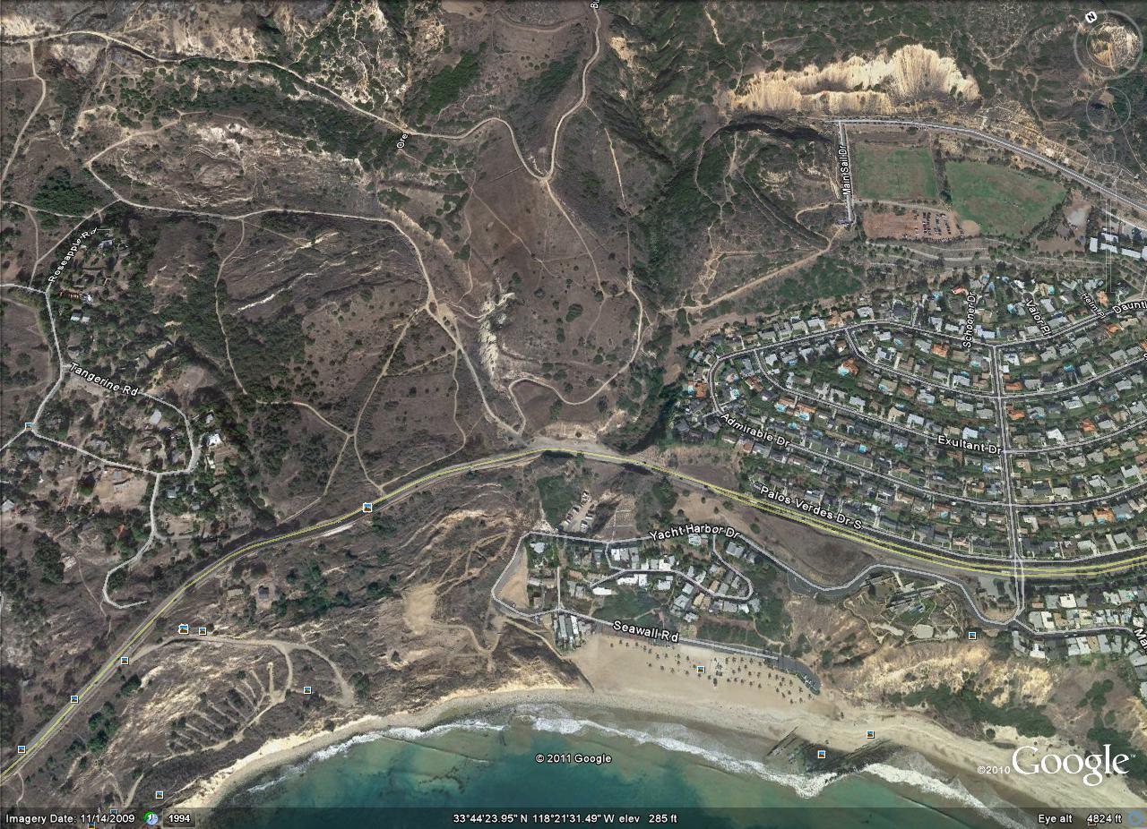
Below are two aerial pictures of the Long Point area of Rancho Palos Verdes at the intersection of Hawthorne Blvd. and Palos Verdes Drive South. The first picture is an aerial photo taken in the 1930’sbefore any development. The only structure is the lighthouse on Long Point which opened in 1925. At this time, Hawthorne Blvd. was known as Crest Road, and did not yet connect over the top of the Peninsula and was part of Crest road across the top of the hill to the Miraleste area.
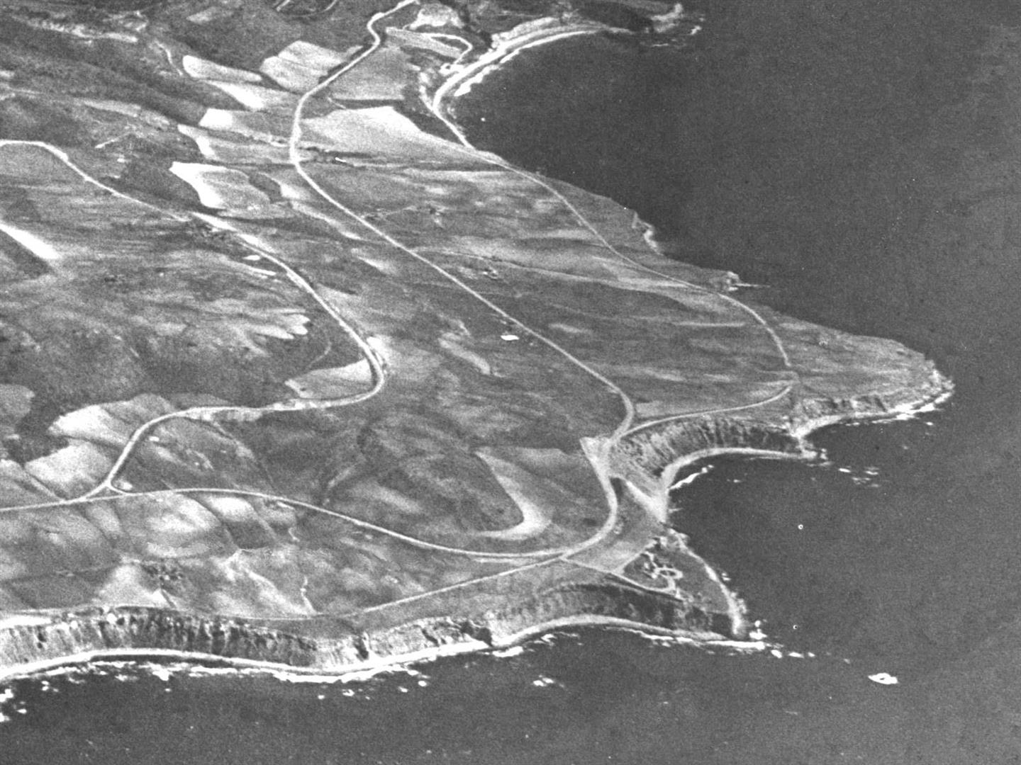
1930’s aerial view of Long Point, with Hawthorne Blvd (then called Crest road ) and Palos Verdes Dr. South
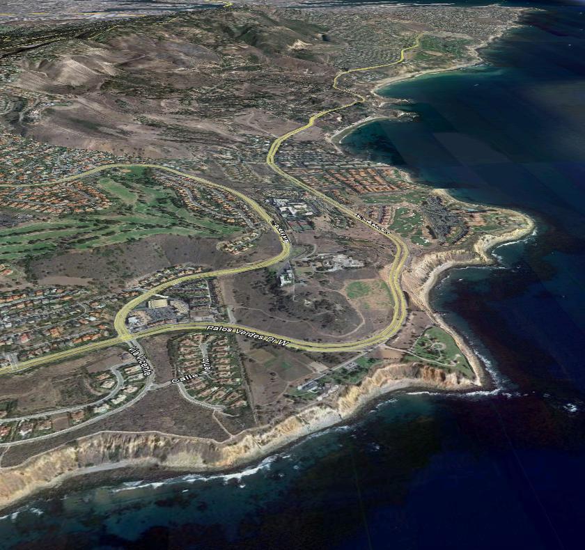
Google Earth view of Long Point
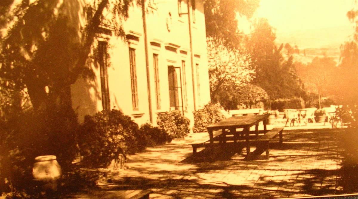
Immediately after purchasing the Palos Verdes Peninsula in 1916, Vanderlip engaged a study to compile weather information about the entire Palos Verdes Peninsula. From the data from that study, Vanderlip determined that the most consistent mild, sunny and fog free weather was in the Portuguese Bend area of the Peninsula. Vanderlip chose this area for the Vanderlip´s summer home, which was constructed in 1916 as the first residence on the Palos Verdes Peninsula other than a couple of ranch houses that no longer exist. The home was copied from their vacation house in Shrub Oak, New York. Vanderlip´s summer home in Rancho Palos Verdes located at 99 Vanderlip Dr., although over 3,800 sq. ft. with 4 bedrooms and 4 baths, was initially called the “Old Ranch Cottage”, and is now known as “The Cottage”.
The Cottage was still owned by Suzanne Vanderlip, the widow of John Vanderlip, the youngest son of Frank Vanderlip, Sr., until her death at the age of 87 on Nov. 17, 2010, and was sold for the first time outside of the Vanderlip family in September 2012 ( I was the Palos Verdes realtor listed on the sale ).
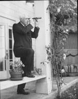
Frank Vanderlip on back porch of The Cottag looking through his telescope at Catalina (photo courtesty of LA Public Library)
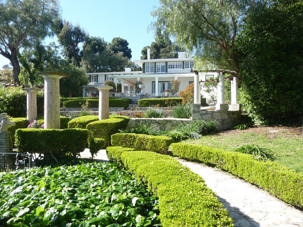
The Cottage in September 2012. Columns in yard were purchased in the 1920’s for Vanderlip’s planned construction of the “Villa Palos Verdes” photo by Bruce Megowan.
Click Here for a Virtual Tour of the Cottage as of 2011 including the original Vanderlip furniture
A larger guesthouse known as the “Villetta” was built in 1924 ( renamed as “Villa Narcissa” for Frank Vanderlip’s wife,. Other buildings were added to the estate in the 1920’s including a small guest house and garage called “La Casetta”. Frank Vanderlip sold La Casetta to the famous character actor Edward Everett Horton, who appeared in many movies including “It’s a mad, mad, mad world ” and also narrated the animated Fractured Fairy Tales segments on the Rocky and Bullwinkle television show.
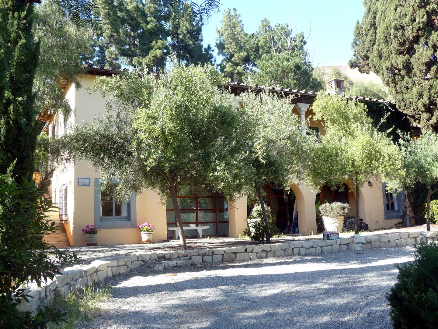
“La Casetta” photo by Bruce Megowan
Behind the Villetta, a beautiful stairway of 268 steps, lined by cypress trees, soared to a spectacular lookout point where a white marble temple semicircle of Doric Columns was built.
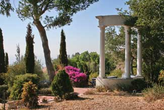
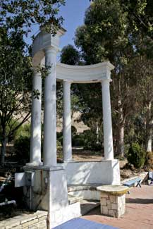
Four Doric columns in a semicircle are reached by the path that defines the garden´s central axis. The pergola was designed by the Olmsted Brothers around 1924.Photos by Guy Nelson
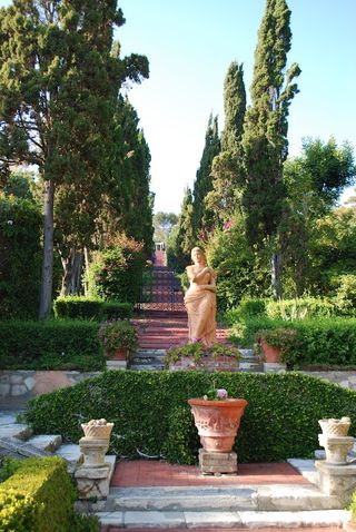
Stairway to the Temple at Villa Narcissa. Photo by Redondowriter
At the top of Narcissa Drive just past the Portuguese Bend Riding Club was the proposed site for the “Villa Palos Verdes“, a grand villa modeled after the Villa Papa Guilio in Italy ( today the Etruscan Museum in Rome ) which he planned to build. The Great Depression put a stop to those plans however, and when Frank Vanderlip died in June 1937, his grandiose plans died with him.
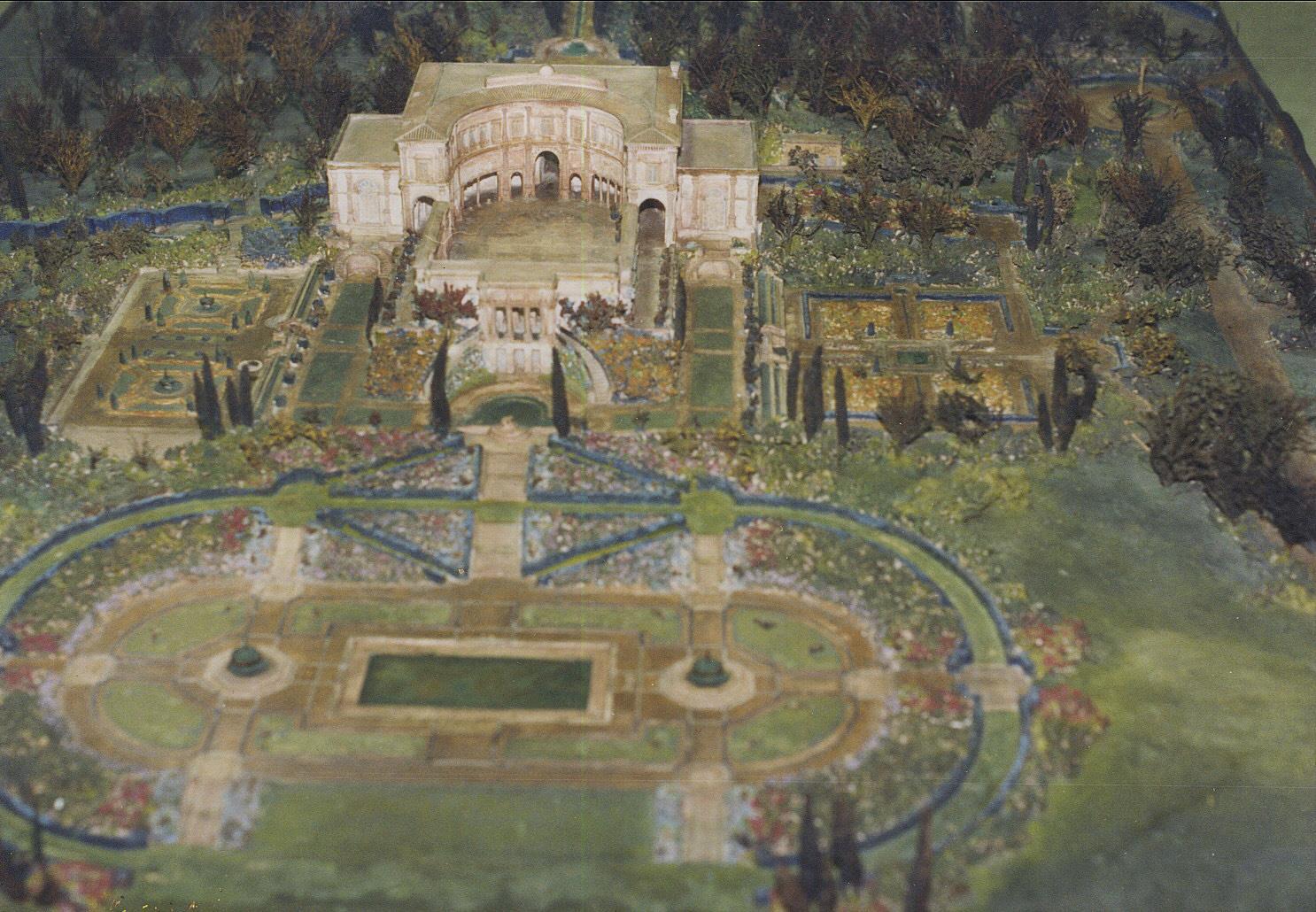
Close-up of Model of original proposed “Villa Palos Verdes “
The Villa Narcissa is located a 100 Vanderlip Drive, at the end of Vanderlip Drive, near the end of Narcissa Drive, the road through a private gated community just south of the Wayfarers’ chapel at the beginning of the Portuguese Bend area, and public access to visit the property is not available.
Villa Narcissa (Picture Courtesy of Palos Verdes Peninsula Library District)
Aerial View showing Vanderlip Mansion estate on left, with staircase with Cypress trees in the rear going up to a “Temple ” , a semicircle of Doric Columns. The Cottage is in the lower center of the picture next to th entrance to the Vanderlip Estate., with “La Casetta” to the right of The Cottage.
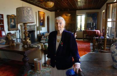
Elin Vanderlip in the Living Room of Villa Narcissa ( photo by Daily Breeze). Elin ( the wife of Kelvin Vanderlip, son of Frank Vanderlip, Sr.) lived in the Villa Narcissa from 1950 until her death in 2009 at the age of 90
Frank and Narcissa Vanderlip
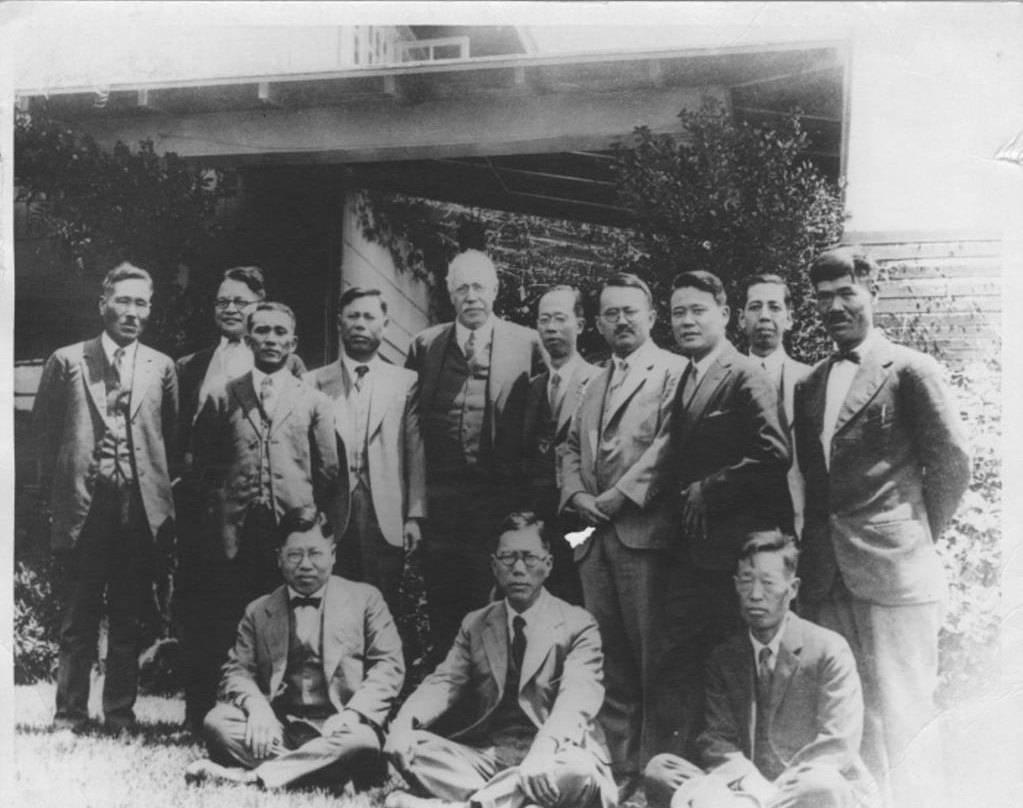
Frank Vanderlip (center rear) meeting in 1928 with Japanese dignitaries at The Cottage, his first estate on the Palos Verdes Peninsula. Nobusuke Kishi, who was to become Japan´s prime minister in the 1950´s, stands second from the left in the back.
A third structure, a barn and stables called the “Farmstead” later became the Portuguese Bend Riding Club.
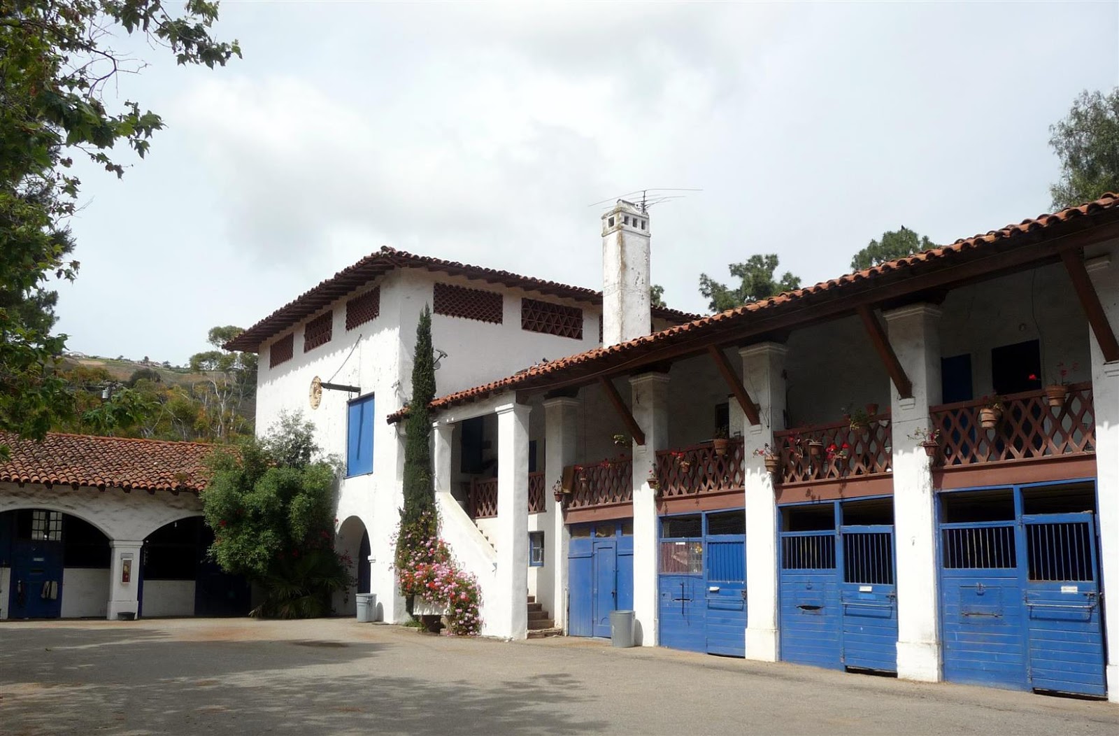
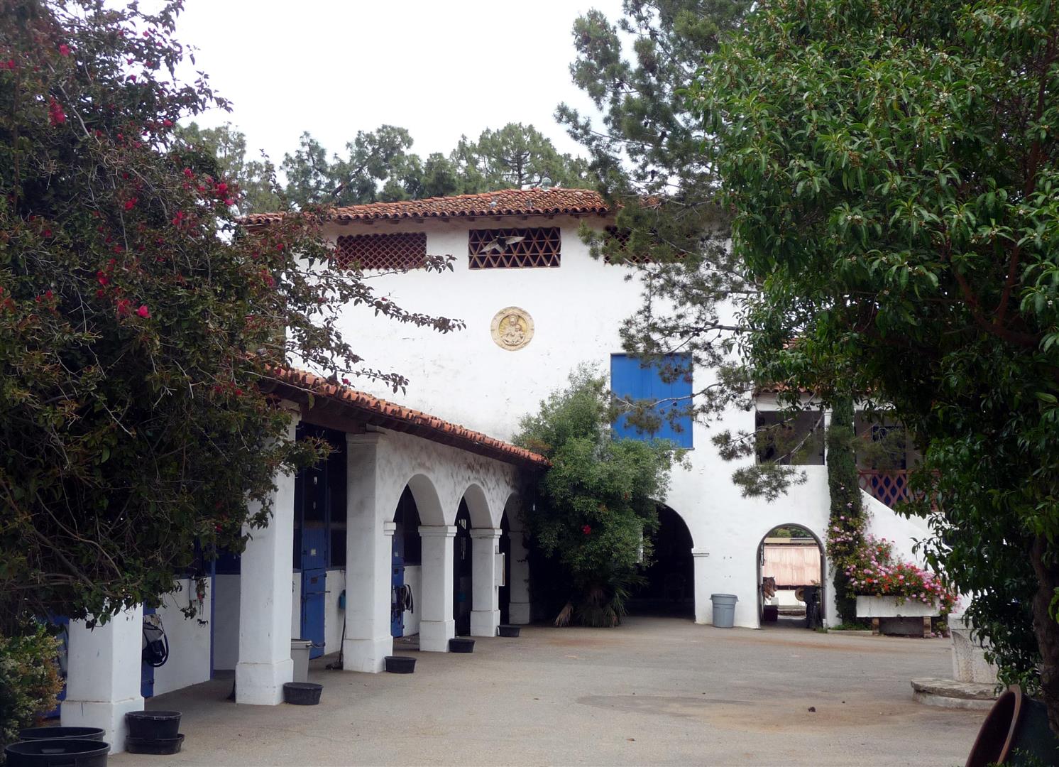
“The Farmstead” – Now the Portuguese Bend Riding Club Photos by Bruce Megowan
For the most part during the 1920’s, Frank Vanderlip lived in New York at his Scarborough-on-Hudson estate “Beechwood”. Frank Vanderlip’s wife, Narcissa Cox Vanderlip, was one of the founders of the League of Women Voters, and was a leading suffragist in New York. She was also a good friend of Eleanor Roosevelt, and was instrumental in her involvement in politics. She and Frank had 6 children (Narcissa, Charlotte, Frank Jr., Virginia, Kelvin, and John).
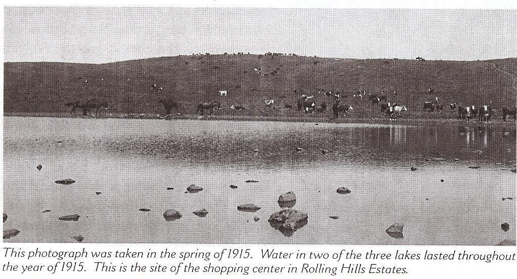
From the early 1900’s through 1945, the area now known as The Peninsula Center on Silver Spur Road was periodically covered by seasonal lakes. Mrs. Frank Vanderlip once stated that the wooded hill behind her home in Portuguese Bend was planted in semi-arid trees by the CCC . This camp may have been located in the Peninsula Center area. The Civilian Conservation Corps (CCC). was established as part of the New Deal during the great depression.
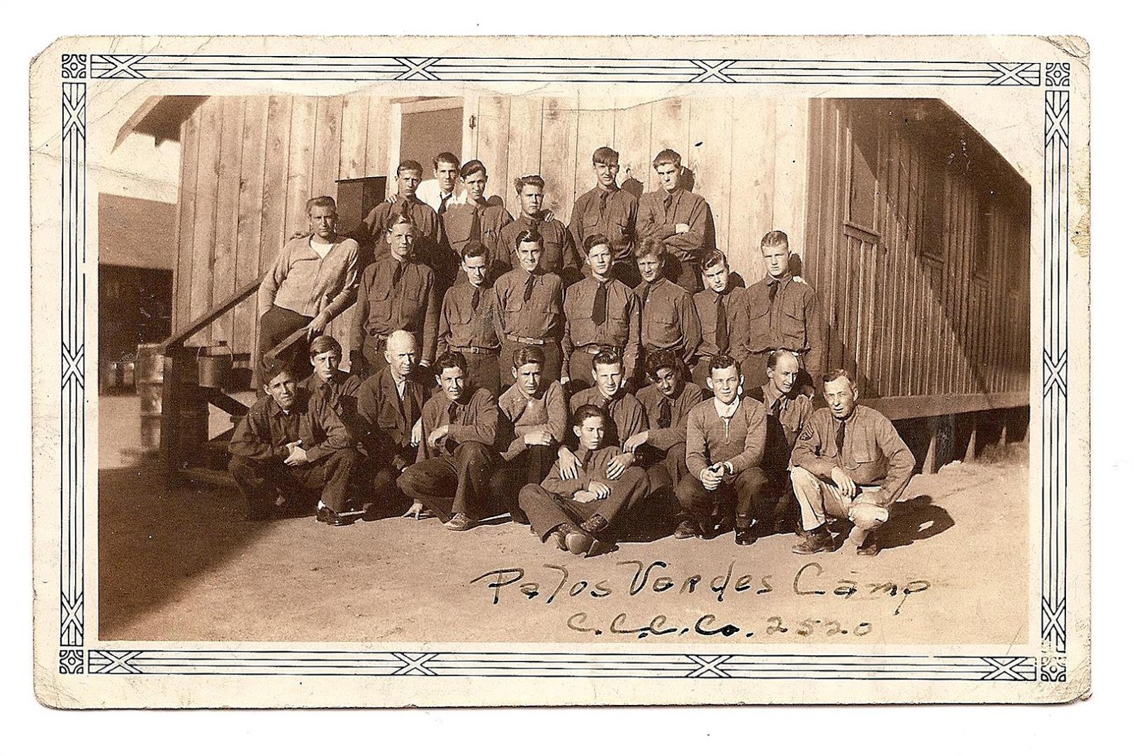
Picture of workers at the Civilian Conservation Corps Camp #2520 at Palos Verdes Peninsula. Camp #2520 printed on the picture above was actually based out of Walla Walla Washington, but it was not unusual for camps to relocate to different areas of the country for a period of time.
Its purpose was two-fold — conservation of our natural resources and the salvage of our young men. The CCC operated from March 1933 to 1942. The CCC planted over 3 billion trees nationwide during its existence, and many of the trees on the Palos Verdes Peninsula may owe their existence to the work of the young men at this camp. The camp consisted of unemployed young men, many of which had dropped out of high school. Most camps also included an education center to teach math and reading.
In Elin Vanderlip’s memoirs, she states that the lakes were drained in 1946 and replaced by a detention camp for prisoners, mainly who were there for missing support payments to their ex-wives. Other records indicate that some of the labor for the construction of Crenshaw Boulevard into Palos Verdes was provided by workers from this detention “honor” camp.
The Palos Verdes Project
In 1919, a syndicate led by Irving Hellman acquired an option from Mr. Vanderbuilt to purchase the entire Palos Verdes Peninsula for $ 3,200.000. His plans were to drill for oil and then to subdivide the balance of the land for home sites. These plans were later abandoned.
In 1921,a real estate developer named E.G. Lewis acquired an option to purchase the 16,000 acre Palos Verdes Peninsula from Mr. Vanderlip for $5 million. By the time Mr. Lewis arrived in Palos Verdes, he already had made and lost a fortune as a mail-order magazine publisher, founder of a bank-by-mail service and builder of a vegetable-dehydration plant. He also dabbled in high-risk mining and oil ventures. He was also reportedly $7 million in debt .The initial development was called the Palos Verdes Project, which would constitute the future City of Palos Verdes Estates and part of the MIraleste area of the present- day City of Rancho Palos Verdes,..The community was called Palos Verdes Estates and consisted of approx. 3225 acres. Ninety percent of the development was zoned for single-family residential architecture.
Mr. Lewis was an entreprenuer and a visionary and was the founding father of two model cities, University City in Missouri ( founded by Mr. Lewis in 1904 in conjunction with the 1904 World’s Fair) and Atascadero, California ( founded as a utopian colony by Mr. Lewis in 1913 ) prior to becoming involved with the Palos Verdes Project. To this day, Colony Days celebration is held in Atascadero every year honoring Mr. Lewis, and he is also held in high esteem and remembrance by the citizens of University City as that city’s founding father. He was also a successful magazine publisher and investor where he made a fortune, but unfortunately later in his life disgruntled investors filed numerous lawsuits against him.
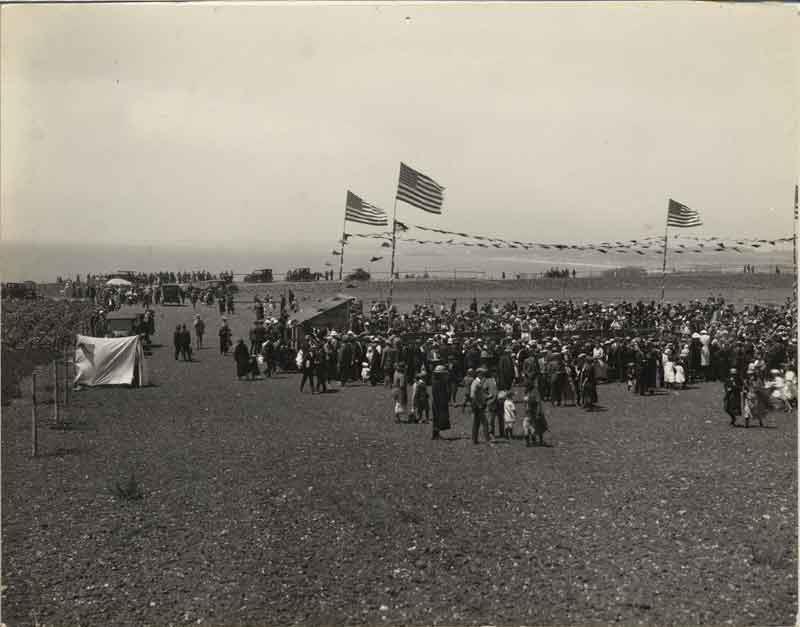
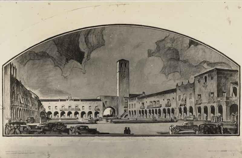
Real Estate Rally in Malaga Cove Plaza to sell lots – 1923
(Picture Courtesy of Palos Verdes Peninsula Library District)
Upon the exercise of the option, and to provide the machinery by which the subdivision was to be laid out and financed, the 3,225 acres were transferred to a trustee, subject to the terms and provisions of a trust indenture commonly known as “Palos Verdes Trust Indenture”. This instrument is still important because it provides for the organization of the Homes Association and defines its purposes and functions, provides for the creation of the Art Jury, defines its purposes and functions, and provides for the drawings and recording of use and building restrictions. The Homes Association , through the Art Jury, still has jurisdiction for aesthetic approval of all architectural plans and modifications of homes in Palos Verdes Estates and the Miraleste portion of Rancho Palos Verdes. The original restrictions on architectural designs also designated three separate districts, with each district having separate guidelines for the architectural style to be used there. For instance, the Malaga Cove area specifically did not allow Tudor style architecture or roofs with sharply sloped roofs, however this style was allowed, to a limited extent, in the Lunada Bay area of the Project.
Early in the history of Palos Verdes Estates, the trustee deeded to the Homes Association 800 acres of the 3,225 acres. By the terms of the deeds transferring these properties to the Palos Verdes Homes Association, the property must be perpetually devoted to public uses; otherwise, title reverts to the trustee. From these 800 acres a golf course was laid out, a swimming club constructed, the La Venta Innerected and the remaining portion planted with trees, shrubs, and flowers, which comprise the parks of PalosVerdes Estates and other planted areas.
Included in the 800 acres are four miles of shore line. Inasmuch as Palos Verdes Estates was an unincorporated area until 1940, the Homes Association was given the power, with the assistance of various county departments, to maintain streets and roads, to maintain parks, to maintain and operate the golf and swimming clubs, and to provide fire and police protection.
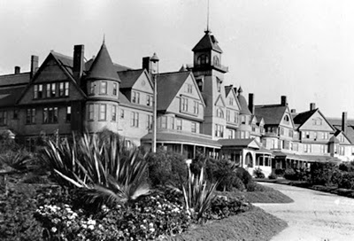
The Hotel Redondo (pictured above ) , which had fallen unto hard times due to the development of the port of San Pedro and prohibition which cost the hotel most of its patrons, was purchased by the City of Redondo Beach in 1922, and then leased to H.G. Lewis for offices for draftsmen and surveyors working on the Palos Verdes Project. Once the first commercial building was constructed in Malaga Cove Plaza, the offices of the Palos Verdes Project were relocated, and the Hotel was closed in 1925, dismantled, and sold for scrap lumber for $300.
It may be hard to envision today, with the extensive landscaping and groves of trees which currently exist on the Peninsula, but the Palos Verdes Peninsula in the 1920’s primarily consisted of coastal sage brush with very few trees. The Palos Verdes Project in the 1920’s and 1930’s employed a large number of gardeners who planted trees and plants throughout Malaga Cove and Valmonte, to encourage investors and potential home buyers to purchase property in Palos Verdes. A very large nursery was constructed on the current site of Lunada Bay Plaza to grow plants to be used by the Palos Verdes Project.

Nursery Constructed at 1005 Via Zumaya in Lunada Bay to supply plants for the Palos Verdes Project (Picture Courtesy of Palos Verdes Peninsula Library District)
The Superintendent of Parks for the Project was Farnham B. Martin. When he tragically died in a car accident, the grassy area next to the Malaga Cove Library was dedicated as “Farnham Martin’s Park”, with a beautiful fountain installed two months later.
A section of 1,000 acres was originally set aside by the planners of the Palos Verdes Project for a University campus. In November 1921, even before Mr. Lewis had acquired the Palos Verdes Project, a proposal was made for the relocation of the southern branch of the University of California (which later was renamed UCLA), which was then located on Vermont Ave. in Los Angeles (built in 1914 and home to Los Angeles City College since 1929). The proposed site was in the center of the Palos Verdes Peninsula where Peninsula High School, the Peninsula Shopping Center, and the Avenue of the Peninsula Shopping Center is located. The proposal, in addition to the donated 1,000 acres, included other inducements. These inducements included $1,000,000, the construction of a model grammar school and a model high school to be run by the University’s Department of Education, a marine biological station and public aquarium, an art museum, a theatre seating 1,500, a boathouse at Portuguese Bend and a football stadium to seat 140,000. After considering 17 other sites, UCLA held classes on their new Westwood campus in 1929.
View of proposed location for UCLA on the Palos Verdes Peninsula
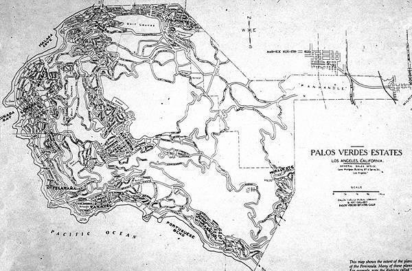
Original Plan for the Palos Verdes Project, then referred to as Palos Verdes Estates, with the large open area in the center planned for the Southern Branch of the University of California.(Picture Courtesy of Palos Verdes Peninsula Library District)
Mr. Lewis had plans to raise $35 million dollars to develop the property by syndicating interests to investors.Mr. Lewis was a grand visionary and also proposed the construction of a monorail with almost no stops between downtown Los Angeles and his proposed site for the Southern Branch of the University of California (UCLA), and including a spur to the Los Angeles Harbor. Mr. Lewis, unfortunately had a checkered past and had been accused of fraud (although he was found innocent of the charges in this link) in several previous investment schemes, including oil wells, almond tree farming, and a magazine. On March 30, 1922, the Los Angeles Examiner published a telegram it had received:
“Suggest you investigate E.G. Lewis before running any more of his adds(sic) if you honestly wish to protect your readers. In one set of circulars he holds out gigantic promises and in another set he sidesteps past due obligations to his thousands of old oil investors.. In my opinion he is paying for his big Palos Verdes advertising campaign with money diverted from investments in his huge unsuccessful doodlebug oil promotion in Montana.”
The cable was signed J.E. McDonald. His history with Lewis was unclear, but he appeared to be a previous investor. After Lewis’ plans for Trust Indenture Notes met with distrust by The Title Insurance and Trust Company of Los Angeles in February 1923, a new real estate trust financed by some 4,000 investors was created, and the revived Palos Verdes Project was again under the financial management of Vanderlip. Mr. Vanderlip retained control of the approx. 13,000 acres of the balance of the Palos Verdes Peninsula that did not constitute the Palos Verdes Project. Mr. Lewis was sued for $20 million by previous investors and in 1925 he declared bankruptcy. In 1927, he was sentenced to six years in federal prison He was paroled in 1931 but was sent back to prison for violating parole. Released again in 1935, he returned to Atascadero, where he spent the rest of his life as a penniless recluse and died in 1950. Regardless of Mr. Lewis’ checkered career, he had a lasting impact on the Palos Verdes Peninsula.
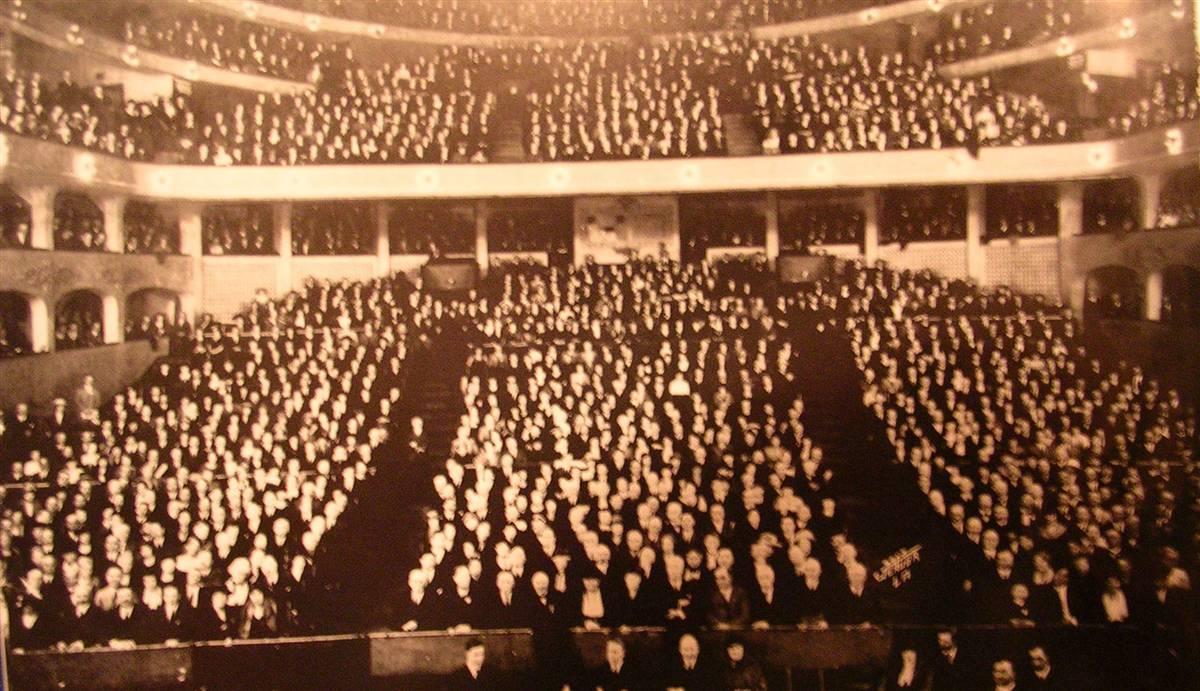
4,229 early investors in the Palos Verdes Project meeting at the Los Angeles Philarmonic Auditorium (Picture Courtesy of Palos Verdes Peninsula Library District)
The Master Plan for the community had been originally drafted by Charles Cheney of the architectural firm Olmsted Brothers. The Olmsted Brothers were also employed to landscape the development. The father of the Olmsted Brothers designed Central Park in New York. The Olmsted Brothers also designed the street layout of Palos Verdes Estates as well as that of the city of Torrance. Planning for the Project included all aspects including the street system, zoning, lot sizes, and planned landscaping. Frederick Law Olmsted, Jr., in a 1923 report, explained landscape design for the northern entrance to Palos Verdes Estates:
“I advise against a large plaza or any other marked demonstration at the property line where it would be liable to be spoiled by developments in contact with it outside the property. I think the most effective treatment at the entrance will be to plunge directly into the wood of Eucalyptus through an opening as narrow as would be practicable and dignified (since the flanking masses are not tall enough to be impressive if the opening is very wide) and after passing through this sylvan gateway for a considerable distance then widen out into an impressive demonstration where the view of the valley and hills and sea can burst upon one.”
Entrance to Palos Verdes from Redondo Beach 1925
(Picture Courtesy of Palos Verdes Peninsula Library District)
After Vanderlip took control of the project, he continued to direct Mr. Cheney in planning the Project. Cheney was the second most important man, next to Frederick Law Olmsted, Jr., on the team. Cheney arrived on the scene about 1921, brought by the then-developer Edward G. Lewis, with whom he developed a scheme for a City Beautiful at Atascadero (San Luis Obispo County, California, 1913). Cheney was a leader in city planning, Director of the National Conference on City Planning, and had experience in California at places such as Riverside, Santa Barbara, Long Beach, Los Angeles, and Berkeley.
Original Conceptual Design of Malaga Cove Plaza by Webber, Staunton and Spaulding, Architects (Picture Courtesy of Palos Verdes Peninsula Library District)
The original master plan was one of the best examples of urban planning of its day, and included architectural restrictions to maintain the Mediterranean design of the Project. These deed restrictions, now enforced by the Palos Verdes Art Jury, are still in effect in Palos Verdes Estates and the Miraleste area of Rancho Palos Verdes.
Malaga Cove Plaza in early 1920s The street signs looked as they do today.(Picture Courtesy of Palos Verdes Peninsula Library District
In addition to the early planned districts of Valmonte, Malaga Cove, Margate, Lunada Bay and Miraleste, located in the current City of Palos Verdes Estates,there were several other planned districts, now part of Rancho Palos Verdes, called “Telarana” (near the Point Vicente lighthouse), “Taravel” (near Long Point), “Cabrillo” (near Portuguese Bend) and “Altamira” (near the Peninsula Center shopping center).
Original plans for Valmonte Plaza (Picture Courtesy of Palos Verdes Peninsula Library District)
The original master plan envisioned three major business centers in Malaga Cove, Valmonte, and Lunada Bay, with minor business centers in Margate, Miraleste, and Montemalaga. The Lunada Bay Plaza area was originally going to be constructed at Via Mirola and was to be a grand plaza with several large buildings, but was ultimately constructed on a scaled down basis a bit north at Yarmouth Road. The only business centers originally planned for the Palos Verdes Project which were constructed were at Malaga Cove, Lunada Bay, and Miraleste.
In 1925, to inform lot owners as to development news in the Palos Verdes Project, the Palos Verdes Bulletin began publishing. This eventually became the Palos Verdes News, still published today.
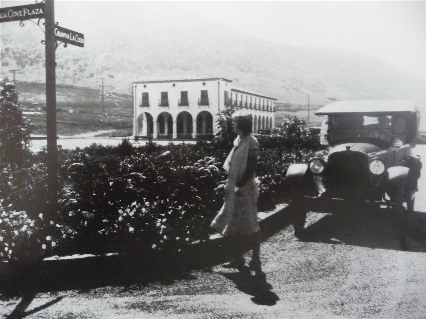
Construction of the first commercial building in Malaga Cove in Palos Verdes Estates, known as The Gardner Building after its developer W.W. Gardner, began in 1924. By the end of 1924, 20 houses were completed or under construction, and 646 lots had been sold. In 1926, the coast road connecting Redondo Beach to San Pedro, previously called Granvia La Costa, now called Palos Verdes Drive West, was completed, including the monumental “Douglas Cut”, which was blasted away above Bluff Cove. Six street entrances were planned for the Palos Verdes peninsula, three from the east and three from the north. The main broad street, Granvia La Costa (Palos Verdes Drive), considered a parkway with a landscaped center strip, was designed for the unrealized Pacific Electric Railway to run down its center.
Formation of the City of Palos Verdes Estates
The Great Depression, which began in 1929, had an extremely debilitating effect on the Palos Verdes Project. Many lot owners defaulted on their property taxes, and the Palos Verdes Homeowners Association, which maintained the Project, was in deep financial straits. Shortly after 1929 the demand for lots greatly diminished, and the trustees and the selling agency were soon without funds. Notwithstanding that these properties were actually devoted to public uses, the land was taxable as private property because it was owned by a California non-profit corporation. In 1932 the trustee turned over to the residents the responsibility of the Homes Association.
By1938 the Homes Association owed the State of California $50,000 for taxes. Needless to say, the Board of Directors of the Homes Association and the residents became concerned for fear the State of California might sell these properties at tax sale, and the community would lose its most valuable assets.An election was held in December, 1939, at which the voters decided to form a city of the sixth class to have taxing authority and to solve the financial crisis.
Immediately upon the organization of the City of Palos Verdes Estates in July, 1940, all of the park lands, the swimming club and the golf club were transferred to the City, and the back taxes were forgiven by the State. The Miraleste section of the Palos Verdes project remained unincorporated, but subject to the deed restrictions of the Palos Verdes Homeowners Association and the Palos Verdes Art Jury.
The Palos Verdes Gatehouse
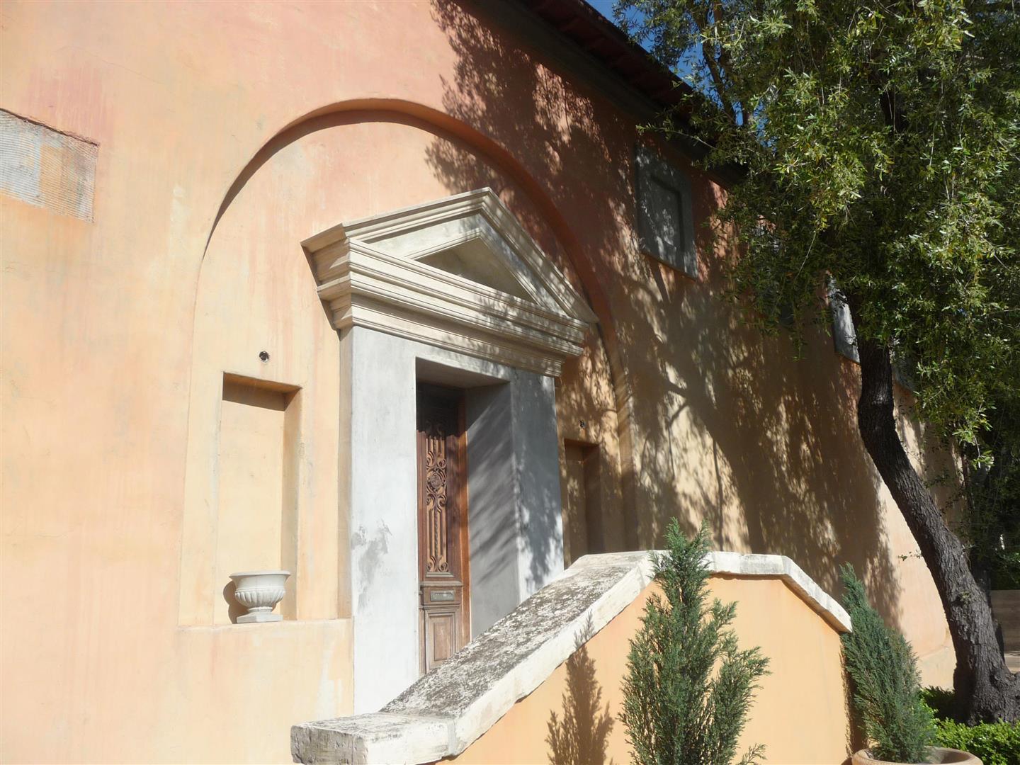
You can see the original gatehouse to the Vanderlip Estate at the gated entrance of Narcissa Drive into the Portuguese Bend community just off of Palos Verdes Drive South. The Gatehouse was built by Mr. Vanderlip and was modeled after an Italian roadside chapel pictured in a 1920 architecture book, which was occupied by Michaelangelo when he received his commission to paint the ceiling of the Sistene Chapel.
Portuguese Bend Gatehouse ( photo by Bruce Megowan )
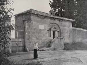
Picture used to design the gatehouse courtesy of Dan Pinkham from “More small Italian Villas and Farmhouses”, by Guy Lowell, Architectural Book Publishing Co., First edition 1920
It has a room off the entrance designed as a chapel with high beamed ceilings, a courtyard off of the chapel, a bedroom, kitchen and a courtyard with a fountain . It is currently occupied and is being beautifully restored by the current owners. The home has also become the center of the Portuguese Bend Art Colony.
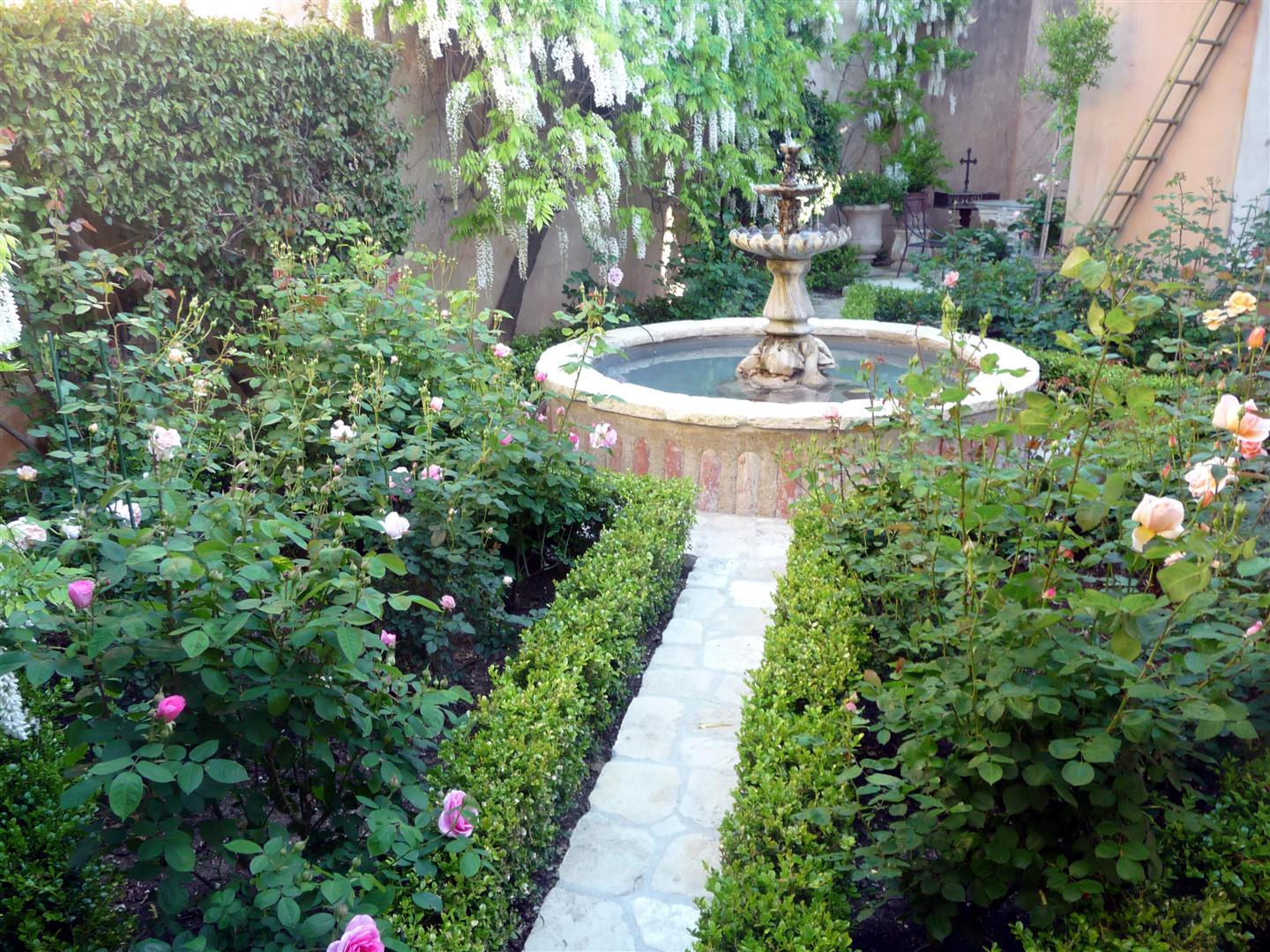
Entrance to Gatehouse Gatehouse rose garden Photos by Bruce Megowan
The Harden House
Across the street from the Portuguese Bend Gatehouse and the entrance to the Portuguese Bend community is a house behind a beautiful Gatehouse. The gatehouse was an exact duplicate of a gate house pictured in a 1920 architecture book.
This house was built by Vanderlip’s beloved sister Ruth and her husband Eddie Harden, a business partner of Vanderlip, in the late 1920’s. Vanderlip had given Ruth the 48 acres of coastal land on the ocean side of Palos Verdes Dirve South. They constructed a five bedroom home with a 6 car garage. They had planned to build a grand villa out on Portuguese Point, but the Great Depression foiled those plans.
The house was constructed in two wings on either side of the gatehouse. On the right wing of the home is a living room, kitchen and two bedrooms, a connecting guest house with a bedroom, and a six car garage. The left wing of the home has another living room, a kitchen, dining room, and two bedrooms. The entrance to both living rooms are off of the gatehouse entrance
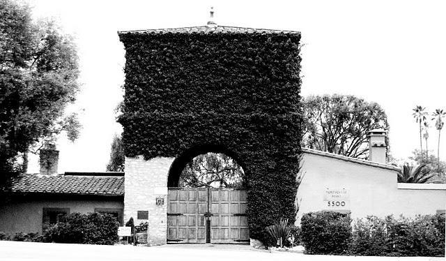
Current day entrance gate to the Harden House Estate, Photo by Tash
Interestingly, the gate entrance to the estate was used in the movie “It’s a mad, mad, mad world” as the entrance to the fictitious “Santa Rosito State Park” and the scene with the crossed palm trees was also filmed on the Harden House grounds.
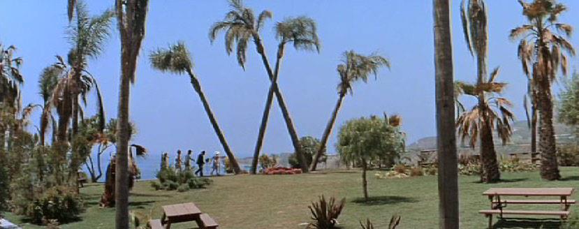
The site of the crossed palm trees “Big W” in the movie “It’s a mad, mad, mad world” is at the upper right hand site of the aerial picture. above
The actual park site of “Santa Rosita State Park” was the grounds of a private residence at Portuguese Point in Rancho Palos Verdes, just south of Abalone Cove Shoreline Park.The crossed palms in the picture above are no longer standing. The parking lot sequences were shot at Peck Park in San Pedro (Western & Summerland, back end of the driveway), with a façade standing in for the gate.
In 1953, Elin Vanderlip constructed a kindergarten in Abalone Cove which was part of the Harden estate for her twin daughters and her other daughter Narcissa and other neighborhood children, which became the current Portuguese Bend Nursery School.
After Ruth died, the Harden House estate was reduced from 48 acres to approx. 2 acres, with the balance of the property acquired by the City of Rancho Palos Verdes as The Abalone Cove Shoreline Park, including Portuguese Point.
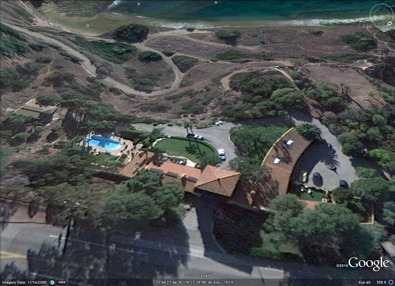
Aerial View of Harden House with Gate Entrance at lower center of the picture.
For additional information and photos of the Harden House, see my web blog entry http://mmegowan.activerain.com/post/4243613/harden-house-for-sale
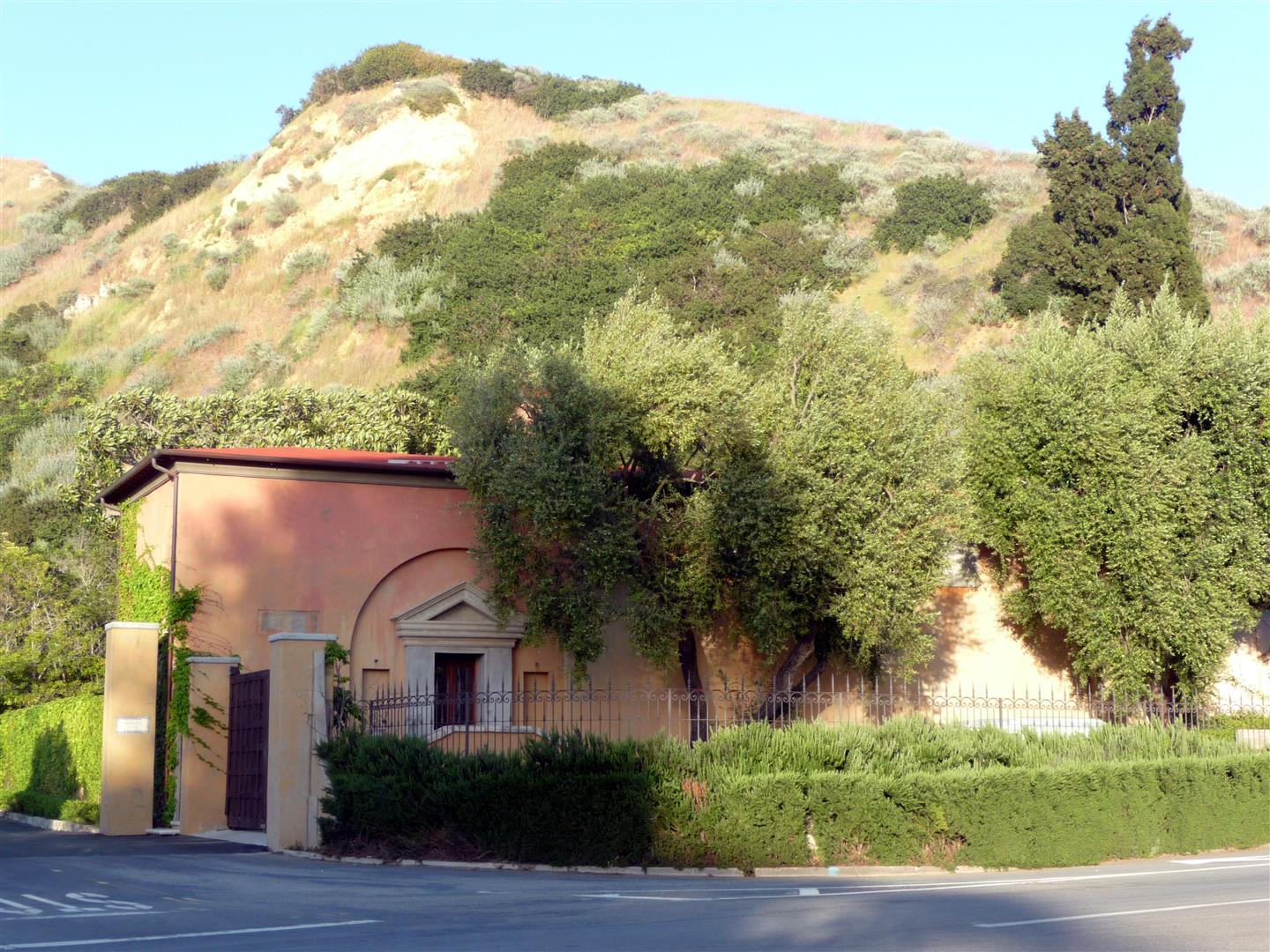
Villa Francesca
Harry Benedict, the personal secretary for Frank Vanderlip, built the “Villa Francesca” as a gatehouse to the other entrance to the Portugeues Bend gated community on Peppertree Drive. He had planned to build a more palatial estate further up the hill, but as the Depression hit, he too abandoned his plans. Elin Vanderlip, in her memoirs tells the story that Frank Vanderlip Sr. , while vacationing in Paris, had cabeled Mr. Benedict just prior to the 1929 stock market crash to sell his stocks, but Mr. Benedict thought better of it and did not, thus costing Mr. Vanderlip millions of dollars. Mr. Benedict also had control of the Palos Verdes Corporation from 1943 to 1945, which owned the Vanderlip family’s remaining ownership of the Palos Verdes Peninsula.
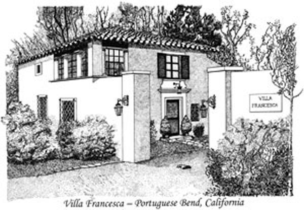
Etching of Villa Francesca by Nancy Backe
The historical marker for Villa Francesca reads : This plaque identifies the estate of Harry E. Benedict (1890-1977). Mr. Benedict, an associate of Frank A. Venderlip, the initial developer of 16,000 acres of the Palos Verdes Peninsula, completed the gate house and the farmstead in 1930, the name “Villa Francesca” honors Mrs. Frances Homberg Benedict, his wife. The architect was Gordon B. Kaufmann, one of Southern California’s masters of the Mediterranean style. The site is listed on the National Register of Historic Places. Dedicated as an historical site October 10, 1987 Rancho de los Palos Verdes Historical Society
Life at Villa Narcissa and The Cottage
During the1940’s, Villa Narcissa, hosted many Hollywood celebrities. Myrna Low, had lived there before World War II, and Paulette Goddard and Burgess Meredith had honeymooned there. In 1946, Kelvin hosted his good friend Ted Geisel (a.k.a “Dr. Seuss”, the famous childrens book author) during the summer. In 1946, Kelvin married Elin Regine Brekke, of Norwegian descent. Dr. Seuss, in 1949, dedicated his book “Bartholomew and the Oobleck” to his godson, Kelvin, Jr., the son of Kelvin and Elin Vanderlip.
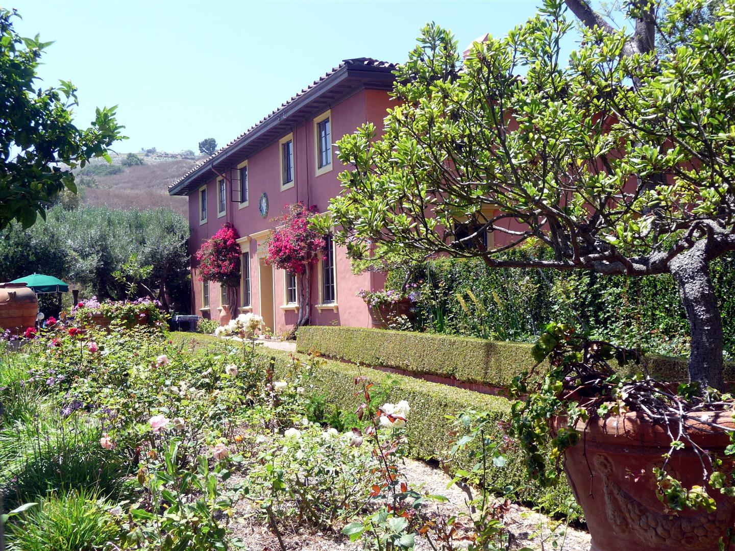
Present Day Photo of Villa Narcissa (photo by Bruce Megowan )
Kelvin Vanderlip built a four room school house that is now the location of St. Peter’s By the Sea Presbyterian Church.
Frank Vanderlip and his family have owned The Cottage and Villa Narcissa since they were constructed. Mr. Vanderlip spent more and more of his time at The Cottage in the early and mid 1930;s until he died in 1937. Kelvin Vanderlip, Frank Vanderlip Sr.’s second son, and his wife Elin occupied The Cottage for the first 5 years of their marriage from 1946 to 1951, when they moved into Villa Narcissa, a wedding present from Kelvin’s mother Narcissa. Frank Vanderlip Jr. then lived in The Cottage from 1951( when Mrs. Narcissa Vanderlip, Frank Vanderlip Sr.’s widow, appointed Frank Jr. to replace Kelvin as the President of The Palos Verdes Corporation) until 1953 when he sold most of the Vanderlip’s remaining interest in the Palos Verdes Peninsula and moved back to New York. John Vanderlip, the youngest son of Frank Vanderlip, Sr.purchased The Cottage from the Vanderlip Estate in 1977 .The Cottage was still owned by Suzanne Vanderlip, the second wife of John until her death at the age of 87 on November 17, 2010, and is now owned by her two children from her first marriage. Villa Narcissa is still owned by the children of Elin Vanderlip, who lived at the estate until her death at the age of 90 in July 2009.
Frank Vanderlip at “The Cottage” (Photos LA Public Library)
The Peacocks of Palos Verdes
Frank Vanderlip Sr. developed a hobby of maintaining a large bird aviary just below The Cottage, which included a number of large bird coops ( at one time containing about 500 birds ) and a large pond providing a haven for migratory birds. The origin of the peacocks that inhabit the Palos Verdes Peninsula is somewhat disputed. Frank Vanderlip Jr. , in an interview, stated that the peacocks were a gift from Lucky Baldwin, a prominent investor and businessman and a friend of Frank Vanderlip Sr. around 1924. In this version, Mr. Vanderlip was visiting with Mr. Baldwin at Mr. Baldwin’s estate in Arcadia, and admired his flock of peacocks that had originally been imported by Mr. Baldwin from India in 1879. Mr. Vanderlip then commented that his Villa Narcissa was “too quiet”, and that Mr. Baldwin then gave Mr. Vanderlip 6 peacocks to “liven the place up”. Elin Vanderlip in her book published shortly before her death, also states that the peacocks were a gift from Lucky Baldwin.This, however, would not have been possible as Mr. Baldwin died in 1909, prior to Mr. Vanderlip’s purchase of the Palos Verdes Peninsula.
Another version has Anita, the daughter of Mr. Baldwin, giving the peacocks to Mr. Vanderlip years after Mr. Vanderlip had admired Mr. Baldwin’s peacocks at Mr. Baldwin’s estate prior to Mr. Baldwin’s death.Yet another version, published by Francine A. Bradley, Ph.D. UC Davis, in a report to the City of Rancho Palos Verdes on managing peafowl on the Palos Verdes Peninsula, states that the original peacock colony on the Palos Verdes Peninsula was a gift of 16 birds from the daughter of William Wrigley, Jr. to Frank Vanderlip, Sr. from Mr.Wrigley’s aviary on Catalina Island. This version was supported by an interview with Mrs. John Vanderlip (Suzanne Vanderlip ) in 2000. One thing that does not seem to be disputed is that in later years, Mr. Vanderlip’s collection of birds ( other than the peacocks ) were donated back to Mr. Wrigley’s aviary on Catalina Island.
Frank Vanderlip at “The Cottage” (Photos LA Public Library)
These birds were maintained at the Vanderlip Estate in Portuguese Bend. It is suspected that some of the birds were introduced to Palos Verdes Estates by former mayor Fred Roessler sometime in the period from 1960-65. There are now numerous peacock colonies in Rancho Palos Verdes in the Crestridge, Vista Grande, and the Portuguese Bend areas, as well as in the Lunada Bay and Malaga Cove areas of Palos Verdes Estates.
Development of Rancho Palos Verdes, Rolling Hills, and Rolling Hills Estates
In 1931, Frank Vanderlip Sr. appointed A.E. Hanson to be General Manager of the Palos Verdes Corporation, which owned the balance of the original Vanderlip property holdings other than that which was incorporated in the Palos Verdes Project. Mr. Hanson was instrumental in the development of the City of Rolling Hills. With the death of Frank Vanderlip in 1937, control of the Palos Verdes Corporation , was passed to Vanderlip’s son Frank A. Vanderlip.
In December 1940, at the depths of the Depression, the Palos Verdes Corporation was deep in debt for unpaid property taxes, and Frank Vanderlip told Mr. Hanson to do whatever was necessary to raise money to pay these taxes. At that time, Mr. Hanson advertised one acre sites, near the Los Verdes Country Club, for sale for $185, however received no takers!
Between 1940 and 1941, the rate of building in Palos Verdes Estates accelerated after being nearly at a standstill during the depths of the Depression. In February 1941, 400% more building permits were issued than during February 1940. When World War II began, the residents of the Palos Verdes Peninsula prepared for war. Unfortunately, this included the internment of many of the Japanese farmers and their families that had lived on the Peninsula for years. Among these families interned were Mas Ishibashi and his wife May, along with their son Satoshi, who was seven years old at the time. They had lived on the peninsula since 1910. May Ishibashi sold strawberries on the side of the road and Mas farmed Rancho Palos Verdes for over 50 years, with the exception of the internment years. Their son Satoshi continued working with his father to farm rolling acres of barley and garbanzo beans for many of those years as well.
Palos Verdes Memorial Garden – Located across from City Hall in Malaga Cove, was rededicated in 1996. Originally dedicated in 1947 to John Bleecker, Hammond Sadler, and Morris Shipley who lost their lives in World War II, the Garden now honors all members of the Armed Services who lost their lives in the line of duty and Police Officers, Captain Michael Tracy and Sergeant Tom Vanderpool, who were killed in service to their City, February 14, 1994.
At the start of WWII, artillery battery installations were installed at the current location of the Rancho Palos Verdes city hall, as well as at Rocky Point in Lunada Bay in 1943 that included two 16 inch guns at each location.They were deactivated in September 1945, and most of the installation was sold for scrap metal. One of the first defensive positions was established at the Haggarty Estate in Malaga Cove. Barracks and support buildings were also constructed in Lunada Bay. An underground observation point was also constructed at Punta Place overlooking Bluff Cove and the South Bay.Lt. Richard Throne wrote about the “Battle of Los Angeles” as follows:
ONE OTHER SINKING TOOK PLACE ON CHRISTMAS 1941 WHEN WHAT WAS THOUGHT TO BE A JAPANESE SUBMARINE WAS SIGHTED OFF OF REDONDO BEACH. THE AIR CORPS AND NAVY RESPONDED AND DROPPED SEVERAL BOMBS. THE ONLY THING SUNK WAS THE OLD FISHING BARGE THAT WAS ANCHORED OFF THE COAST.
WHAT WAS LEFT OF THE BARGE WASHED ASHORE ON THE BEACH AT MALAGA COVE, IT WAS QUITE AN ATTRACTION FOR SOME TIME AND A NUMBER OF ITS PARTS WERE SALVAGED BY LOCAL BOYS. (Source: Oral History of Palos Verdes Estates Police Department )
The current location of the Interpretive Center in Rancho Palos Verdes was used by the Army as a practice shooting range. This resulted in extensive environmental remediation when the Interpretive Center was renovated and expanded in 2004-2005, due to lead contamination in the soil from the projectile portion of the bullet.
In 1943, control of the Palos Verdes Corporation was passed to Harry Benedict, a friend and business associate of Frank Vanderlip Sr. . In 1945, Kevin Vanderlip took control of the Corporation as President. Kelvin believed in furthering his father’s vision of the development of the Palos Verdes Peninsula into large estate sized lots such as were being sold in the Rolling Hills development. Frank Jr., however was unwilling to sell off individual lots due to the extremely high income tax rates on ordinary income at that time ( in excess of 90% at higher income levels). In 1951, Narcissa Vanderlip, the mother of Kelvin and Frank Jr., appointed Frank Jr. as President of the Palos Verdes Corporation and demoted Kelvin to Vice President. Kelvin then promptly resigned at his displeasure of this decision, and went on to a very successful career at the architecture firm Welton Beckett until his death from lung cancer in 1956.
From the early 1900’s through 1945, the area now known as The Peninsula Center on Silver Spur Road was periodically covered by seasonal lakes. In Elin Vanderlip’s memoirs, she states that the lakes were drained in 1946 and replaced by a detention camp for prisoners, mainly who were there for missing support payments to their ex-wives. Other records indicate that some of the labor for the construction of Crenshaw Boulevard into Palos Verdes was provided by workers from this detention “honor” camp.
Probably the greatest single event that would shape the future of Rancho Palos Verdes occurred in 1953. Since 1944, the Great Lakes Carbon Corporation had leased a 300-acre tract of land on the north side of the Peninsula for mining of diatomaceous earth (the remnants of this mine can be seen at the southwest intersection of Hawthorne Blvd. and Via Valmonte). Although this mines resources had nearly been exhausted, another rich deposit was known to exist on a 165-acre tract near the crest of the Peninsula. For two years, the Great Lakes Carbon Corporation had been unsuccessfully attempting to purchase this property from the Vanderlip family. Finally, Frank Vanderlip Jr. agreed to sell, provided that Great Lakes purchase all of the stock in the Palos Verdes Corporation for about $9 million, so that the sale would be taxed at capital gains rates. Upon completion of the transaction in December 1953, Great Lakes Carbon Corporation suddenly owned 6,800 acres of prime undeveloped land, all that was left of the 16,000 acres bought from Mr. Bixby, with the exception of 500 acres retained by the Vanderlip family in the Portuguese Bend area.
What happened next was not surprising. The plans for mining operations were quickly discarded when it was discovered that the quality of the dicalite deposit was not good and a group of well-known architects and engineers were hired to create a master plan to develop the property. Great Lakes also formed a 79%/21% partnership with Capital Company, an experienced real estate firm.Capital Comany, in the late 1930’s became a subsidiary of Transamerica Corp. and in 1964 changed its name to Transamerica Development Co.
In response to the changing circumstances, the other three Peninsula cities of Palos Verdes Estates, Rolling Hills and Rolling Hills Estates incorporated before the largest building boom began in the late 1950 and early 1960s. Fueled by the master plan created by the Great Lakes Carbon Corporation and the burgeoning economic growth occurring in the South Bay area, the remaining unincorporated area on the Peninsula began to develop rapidly and in ever-increasing densities.
On April 1, 1950, the Palos Verdes Peninsula had about 6,500 residents, and by June 1967, the number of residents had grown to approx. 54,000.
Great Lakes Carbon Corp. began to operate its real estate holdings through a subsidiary, Great Lakes Properties, Inc. In addition to its development activities on the Palos Verdes Peninsula, they also developed the Del Amo Financial Center in Torrance.
In September 1955, Palos Verdes Properties, Inc. sold the first 117 acres of the 6,800 acres that Greak Lakes Carbon Corp. and Transamerica Developement had purchased in 1953 to McCarthy Co., land developers. In May 1956, one of the largest land sales took place with Ed Zuckerman and other investors for 1,000 acres known as Grandview Palos Verdes, located near Montemalaga Drive and Silver Spur Road for $6 million. The Monaco development of 180 acres was begun in September 1959. By 1967, only about 1,600 acres remained to be developed.
In 1961, a 400 acre science research park was proposed at the intersection of Hawthorne Boulevard and Crest roads, in an area that was later annexed by the City of Rolling Hills estates (see the History of Rolling Hills Estates for more detail on this proposed development). This area, near the intersection of Highridge and Crest roadwas also proposed to be the location of a state college (later to become Cal State University Dominquez Hills), however the eminent domain lawsuit to purchase the property from Northrop Corp. and Palos Verdes Properties as well as other owners was abandoned by the state in mid-1965 due to escalating land values.Two other sites on the Palos Verdes Peninsula were then considered, including one on the northern slopes of the Peninsula including the Chandler gravel pit and the County sanitary landfill on unincorporated land between Crenshaw and Hawthorne Boulevards, as well as on land overlooking Palos Verdes Drive South in Rancho Palos Verdes adjacent to San Pedro. Neither of these two Palos Verdes sites were approved however, andthe campus was later located in Carson as the California State University, Dominquez Hills
Palos Verdes Peninsula Road Development
Road Construction on the Palos Verdes Peninsula did not take place until the 1920’s. Palos Verdes Drive West in the Valmonte and Malaga Cove area was the first road developed as part of the original Palos Verdes Project. Palos Verdes Drive East in the Miraleste area, then known as Western Ave. and which was then part of the Palos Verdes Project, was then developed to facilitate lot sales there. Palos Verdes Drive North was completed in the mid 1930’s
Early road construction in Palos Verdes Estates Malaga Cove and Valmonte area
In 1926, the coast road connecting Redondo Beach to San Pedro, previously called Granvia La Costa, now called Palos Verdes Drive West, was completed, including the monumental “Douglas Cut”, which was blasted away above Bluff Cove.
Douglas Cut (Picture Courtesy of Palos Verdes Peninsula Library District) Construction of Palos Verdes Coast Road at Bluff Cove Douglass Cut
Road Construction of Palos Verdes Drive West and Yarmouth Road – Site of Lunada Bay Plaza and 1920’s Lunada Bay
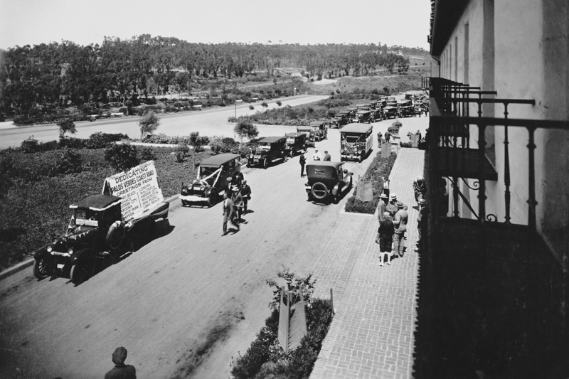
Dedication of Palos Verdes Coast road caravan of cars forming at Malaga Cove Plaza
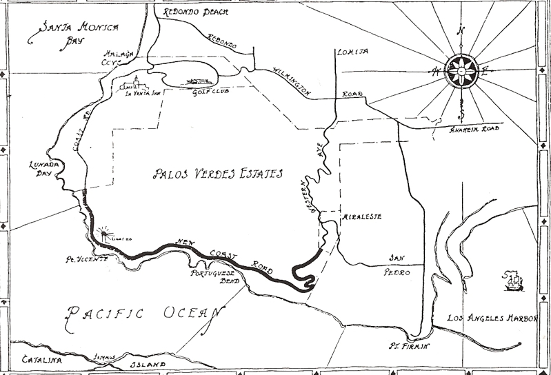
Above is a 1927 map showing the recently completed new coast road ( Palos Verdes Dr. South) in darker bold line. This road had not yet been named Palos Verdes Drive and was simply referred to as the Coast Road. Note that it shows connecting to “Western Ave”, which later was renamed Palos Verdes Drive East and now runs into Narbonne Ave on the north. Western Avenue later was constructed between Narbonne/Palos Verdes Drive East and Gaffey Street in San Pedro. Also notice that Pacific Coast Highway was named Redondo and Wilmington Road at that time and connected to Anaheim Street at the current junction with Western Ave. Palos Verdes Drive North had also not yet been constructed.
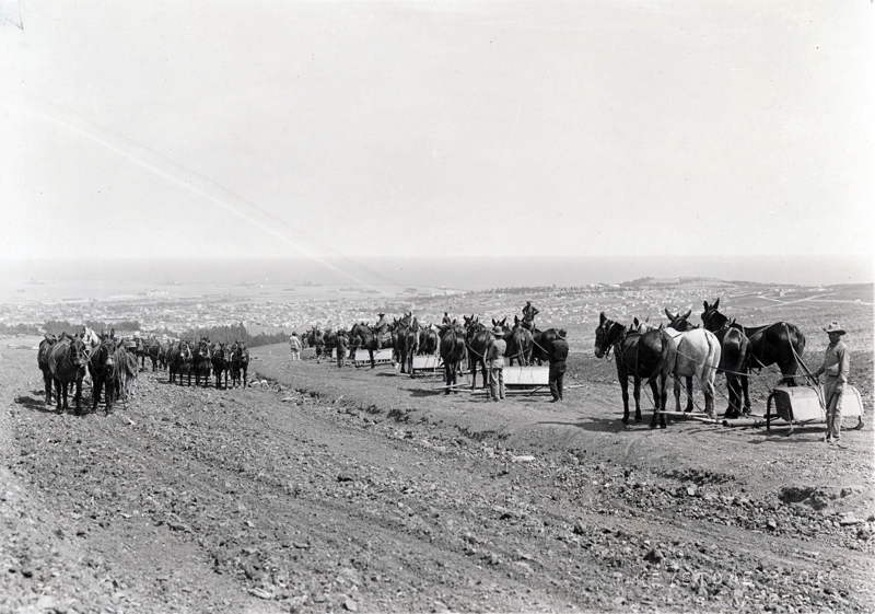
Early road construction on Palos Verdes Peninsula. May be construction of Crest Road ( Note port of Los Angeles in background )
Late 1930’s Sales Brochure Map of Palos Verdes Roads. Note Western Ave. was not yet constructed. Pacific Coast Highway was known then as “State Street ( Highway 101”) .Palos Verdes Drive North was completed in the early to mid 1930’s.
Road construction moved forward rapidly in the late 1950’s and through the mid 1960’s..Construction of Crenshaw Boulevard up a canyon from Palos Verdes Drive North to Silver Spur road commenced in mid June 1950. and was completed in September 1951.
Above is a 1949 Road map showing planned extension of Crenshaw ( dotted line ) from Torrance to Palos Verdes Drive south, Hawthorne Blvd. ending in Torrance , and Crest Road extending down to Palos Verdes Dr. West/South . Crenshaw used to terminate at the entrance to Rolling Hills, and when extended into Rolling hills to Crest road, the old portion of Crenshaw going into Rolling Hills was renamed Rolling Hills Road. Also notice the new Western Ave. which had not yet been extended into San Pedro.
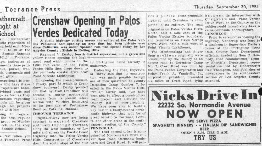
Labor for the construction of Crenshaw included that of inmates at County Detention Camp No. 7 in the Palos Verdes Hills. An article in the Torrance Press on the opening day of Crenshaw Blvd. on September 20, 1951 had the following quotes:
“Dedicating the road, Supervisor ( Raymond V. ) Darby said that its construction was made possible through use of men quartered at County Detention Camp Number 7, located In the Palos Verdes Hills.. “Thus,” Darby said, “we have been able to effect a constructive road project and alleviate the County jail of over-crowding.We have been able to build a key link in a badly-needed north/south highway that will be of great benefit to Torrance, Lomita and other areas in the southeastern section of the County.”The road opened today is comprised of Montemalaga Drive, Silver Spur Road, Crenshaw boulevard and Crest Road. It will provide a public cross-peninsula highway until Crenshaw is completed in its entirety. The road originates on Palos Verdes Drive North, half a mile east of the Palos Verdes Estates boundary, and terminates on Palos Verdes Drive West, half a mile west of Point Vicente Lighthouse.
The Montemalaga ‘and Silver Spur sections originally were constructed by the County as an access road to Detention Camp No. 7. Crest Road was built by the Palos Verdes Corporation and today Frank A. Vanderlip, Jr., corporation president, presented 4.2 miles of Crest Road, lying between its intersection with Crenshaw and Palos Verdes Drive West, to the County so the Public would immediately have a cross-peninsula thoroughfare.”
The extension of Crenshaw from Crest road to Palos Verdes Drive South was never completed due to the Portuguese Bend landslide in the mid 1950’s which was triggered by road grading for the extension of Crenshaw Blvd.
The extension of Crenshaw from Palos Verdes Drive North to Silver Spur was not completed until 1959 as a two lane roadway. This roadway was so dangerous, after several fatal accidents the road was expanded to a 4 lane road opening in 1967.
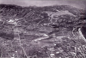
Above is an early aerial view, probably in the mid 1930’s, of South Torrance and the Palos Verdes Peninsula. Note that Hawthorne Blvd had not been extended into the Peninsula, and Crenshaw had also not yet been constructed.Hawthorne Avenue veared right into Palos Verdes Estates at what is today called Viia Valmonte. The light area in the upper left of the picture is the former Palos Verdes Landfill site which was then being mined for dicalite. Pacific Coast Hwy runs left to right in the middle of the picture, and above that is the recently constructed Palos Verdes Drive North. The Hollywood Riviera project is in the far right center of the picture. Western Ave had also not yet been completed through San Pedro which would be completed in the mid 1950’s
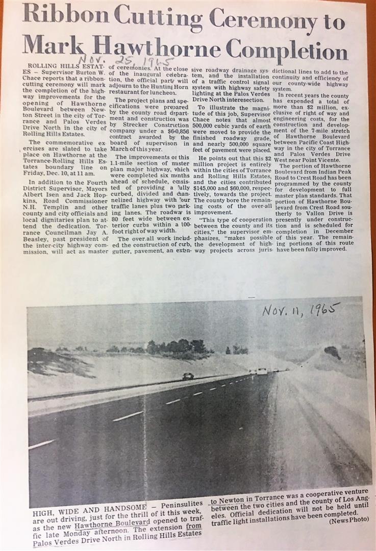
Construction of Hawthorne Blvd. through the Peninsula was completed in several segments. Hawthorne Blvd. was completed from Silver Spur Road to Crest in 1959. The segment from Palos Verdes Drive North to Silver Spur Road was completed in 1961. After several years of planning, the final segment extending Hawthorne Blvd. from Newton in Torrance to Palos Verdes Drive North was completed in November 1965.
Founding of the City of Rancho Palos Verdes
The idea of a fourth city was first advanced in 1962 as an answer to controlling the unbridled development that was occurring in the unincorporated areas on the Peninsula, which remained under the control of Los Angeles County. Unfortunately, these early efforts were never able to get off the ground. In early 1965, the City of Palos Verdes Estates attempted to annex a portion of present day Rancho Palos Verdes totaling 2.92 square miles bordered by High Ridge Road to the east and the Pacific Ocean, including the Marineland Park, in an attempt to broaden its tax base. See LA Times Article. This effort failed, however. Then, in 1969, came the new County Master Plan for the Peninsula that provided for a population density far beyond what the local residents wanted. In response, a Peninsula-wide organization was formed that same year called Save Our Coastline (SOC). Unlike previous efforts, SOC was able to combine political and financial power with experienced local governments focused on achieving a common goal. However, after several unsuccessful fights against the Countys Master Plan for the Peninsula, it became evident that the only way to preserve the environment and to gain control over local zoning issues was through incorporation of a fourth city.
The election to incorporate Rancho Palos Verdes was finally held on August 28, 1973. An overwhelming majority of 5 to 1 voted in favor of incorporation.
The first City Hall offices were located in the former SOC offices in the Golden Cove Center at the corner of Hawthorne Boulevard and Palos Verdes Drive West. One of the first actions taken by the new City Council was to declare a building moratorium and to begin work on the preparing the Citys General Plan. Today, there is a broad range of real estate options in Rancho Palos Verdes, ranging from condominiums, townhomes, and townhouses, to luxury homes and estates.
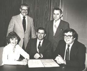
The first City Council seated left to right,Marilyn Ryan, Gunther Buerk, and, Robert Ryan. Standing Left to right, Dave “Cisco” Ruth and Ken Dyda
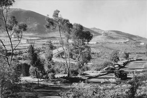
In 1955, in response to the threats of the cold war, a Nike missile site was constructed at a site above the current Golden Cove Shopping Center, but by 1974 these Nike missile sites had become obsolete and were shut down by the Federal government. In 1975, Rancho Palos Verdes City Hall was relocated to its current location at the former Army Nike missile base.
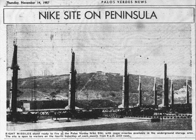
The two large round white buildings visible from Palos Verdes Drive East at the top of the hill house a radar facility that is still operational. It is run by the Federal Aviation Administration which continues to use the facility for long-range radar. The Los Angeles Air Route Traffic Control Center uses the facility to control air traffic into and out of Los Angeles. The FAA took over the faciltiy from the U.S. Air Force in 1960. The radar control site for the Nike missile launch facility formally at the Rancho Palos Verdes City Hall was located at present day Del Cerro Park, at the southernmost end of Crenshaw Boulevard.
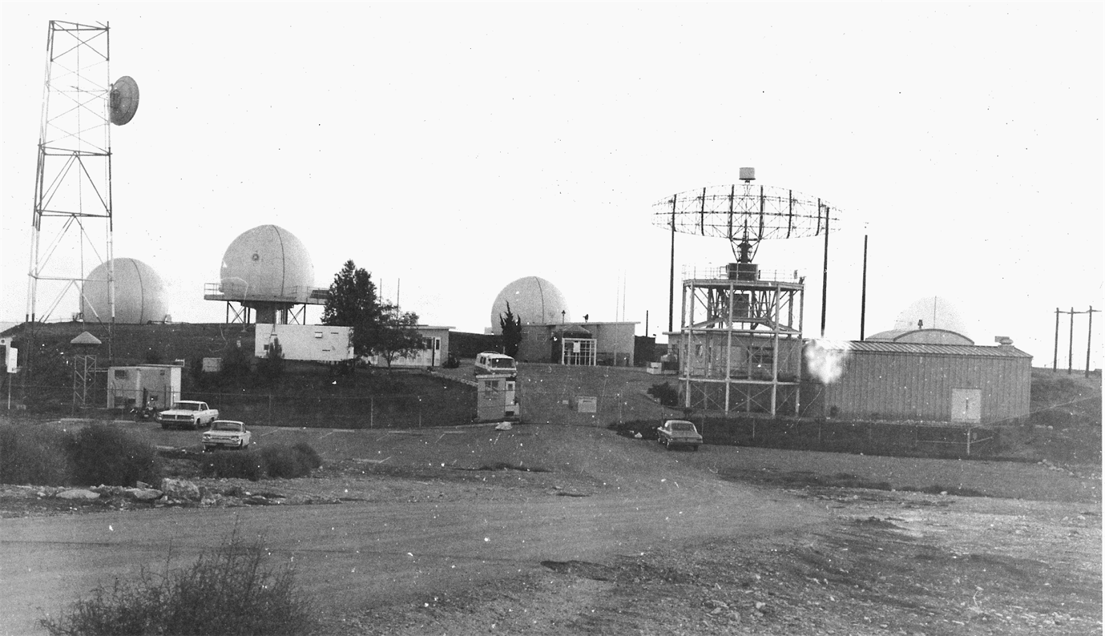
Nike Radar control site at present-day Del Cerro Park (photo courtesy of Ed Sharpe )
Palos Verdes Schools
Palos Verdes school students, prior to 1925, attended schools in Redondo Beach, which was then part of the Los Angeles City School District. A separate Palos Verdes school district was created in 1925, however it was only for grades K-8. The first school constructed, in 1926 in Malaga Cove, housed all school grades from elementary school through eighth grade,with high school students continuing to attend schools in Redondo Beach. During the construction of Malaga Cove School, students temporarily attended classes in the Gardiner Building in Malaga Cove Plaza.
Palos Verdes High School was originally planned and constructed as a six year school for grades 7 through 12by the Los Angeles School District in 1960, but when the Palos Verdes Unified School District was formed to include high schools as well as grade school students, the partially completed campus of Palos Verdes High was converted to a high school in 1961 as the first high school of the the Palos Verdes Unified School District. When the school opened, construction was not complete. Some classes had to be held in the lunch area and others met in the school buses. (PVPUSD owned a large fleet of yellow school busses at that time.)
Originally, the school had a print shop and an auto shop, but both were never used for those purposes.The architects idea was that students should look inward and study should be centered in the classroom. For that reason none of the rooms had windows other than a narrow set of louvers at the top.
Prior to the opening of Palos Verdes High School, high school students on the Peninsula attended such schools as Redondo Union High and Narbonne High. Rolling Hills High School opened in the fall of 1964 for grades nine through eleven. Seniors stayed at Palos Verdes High School. Miraleste High opened in 1968. In 1991, due to declining high school enrollment, the three high schools were consolidated on the campus of Rolling Hills High School, and renamed Palos Verdes Peninsula High School. “Peninsula High School” was the name that was supposed to have been given to the 4th high school that would have been built on the land across Crestridge Rd. from Ridgecrest Intermediate School. However, that school was never built, the land was sold for $6,000,000 to a developer (which caused quite a furor since many thought it was below market value) and so when the “consolidated” high school was named, it got the Peninsula High name.
At the time of consolidation, Palos Verdes High and Miraleste High were converted to intermediate schools, and the former intermediate schools at Malaga Cove and Margate were closed and temporarily leased to other preschools and prep schools. When Palos Verdes High school was reopened in 2002 (with just freshman and sophomores), the school at Margate was reopened as Palos Verdes Intermediate School, and Ridgecrest Intermediate School was converted from an elementary school site soon after. Palos Verdes High School and Peninsula High School are open enrollment schools, therefor any student in the district may attend either high school.
Malaga Cove School,as it looked upon completion in the Spring of 1926. (Picture Courtesy of Palos Verdes Peninsula Library District)
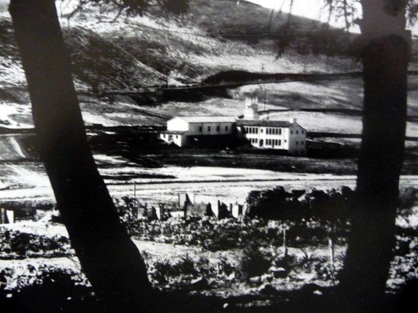
In addition to Marymount College in Rancho Palos Verdes, another college used to be located on the Palos Verdes Peninsula. In 1947, Palos Verdes College, a small, private, independent junior college opened at the current site of Rancho del Mar High School in Rolling Hills. The college initially occupied barracks which were used in WWII. The college, at its peak, served approximately 100 students. Some of the college’s students included Elizabeth Taylor’s brother, and Leslie Caron, the film star. The college had plans to construct a permanent campus, however fund raising was never adequate to realize these dreams, and the campus closed in 1955. The barracks buildings were used as administrative offices for the Palos Verdes School district after the college’s closing.
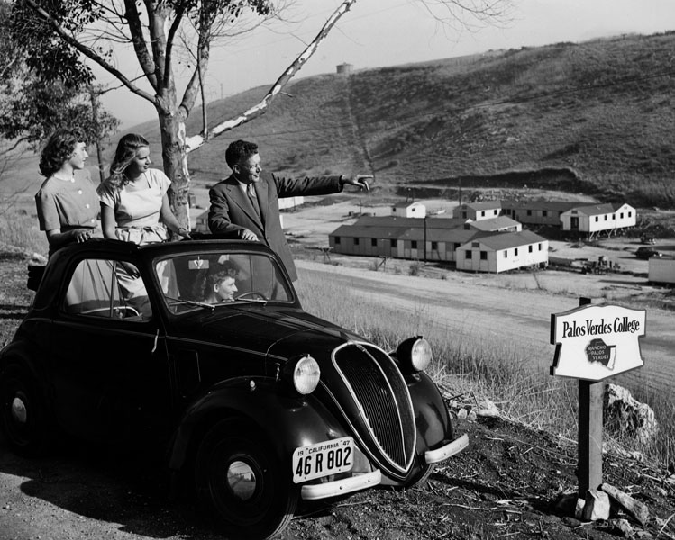
Palos Verdes College. Photo dated: September 12, 1947. (LA Times Photo)
Palos Verdes State College:
In 1963, Great Lakes Property, Inc., had planned to sell 107 acres of land near the intersection of Hawthorne Boulevard and Crest road at the top of the Palos Verdes Peninsula as a site for what was originally named South Bay State College and then renamed California State College at Palos Verdes (CSCPV). The State of California had allocated funds to acquire this land and had actually begun classes for 27 freshmen and 14 juniors in a bank building in the Peninsula Center area in September 1965..
After extensive planning and beginning eminent domain acquisition of the site, due to rising land values this site was abandoned for consideration in mid 1965.Three other sites on the Palos Verdes Peninsula were then considered, including one on the northern slopes of the Peninsula including the Chandler gravel pit and the County sanitary landfill on unincorporated land between Crenshaw and Hawthorne Boulevards, as well as on land overlooking Palos Verdes Drive South in Rancho Palos Verdes adjacent to San Pedro. Other potential sites included Fort MacArthur in San Pedro and Dominquez Hills.
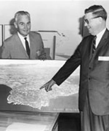
Officials pointing to newly approved California State College at Palos Verdes
After the Watts riots in South Central Los Angeles in August 1965, however, one of the issues raised by civil rights leaders was the lack of access to colleges in the area. In response, the California legislature decided not to approve the Palos Verdes sites and the campus was located in Carson as the California State University, Dominquez Hills.
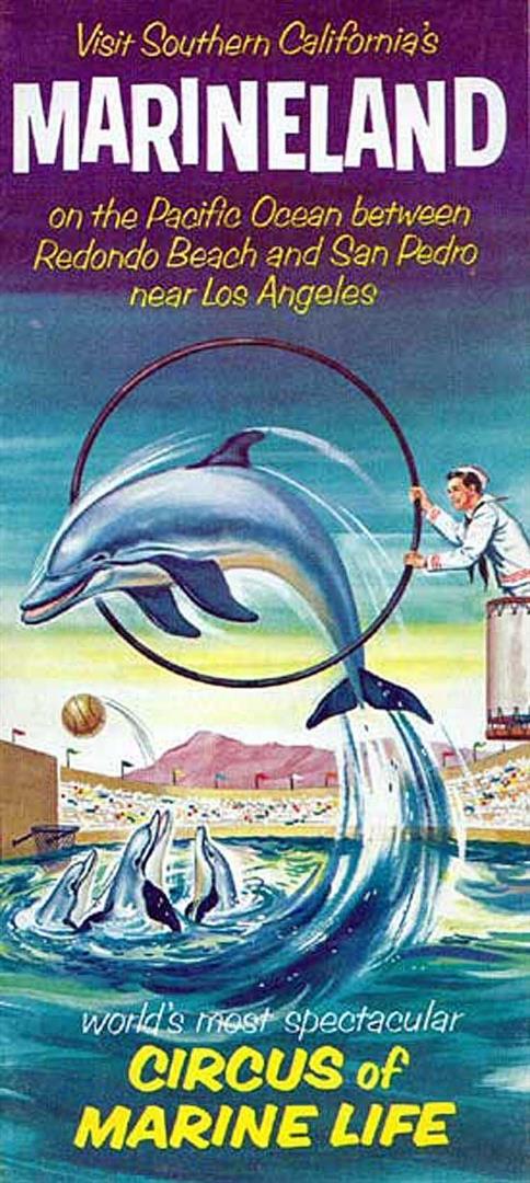
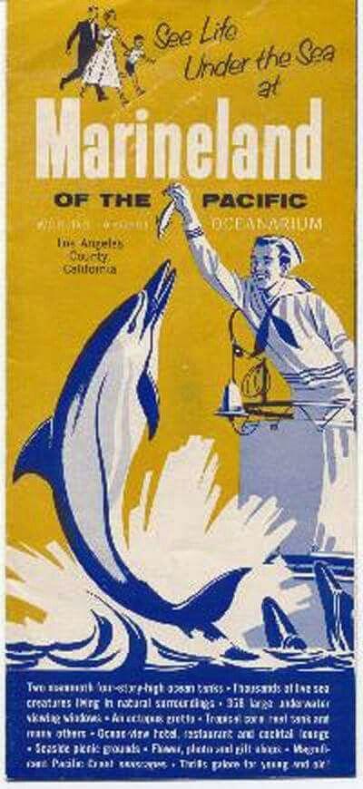
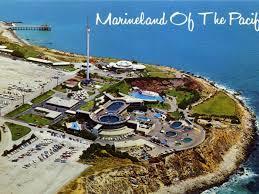
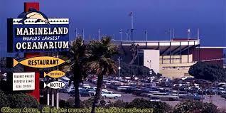
Marineland
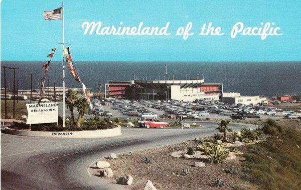
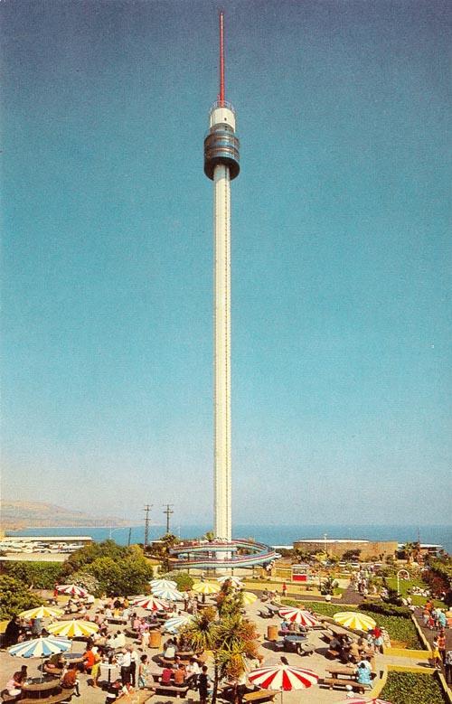
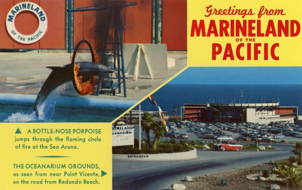
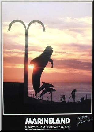
Marineland of the Pacific, which opened in 1954, for many years provided the primary tourist attraction in Rancho Palos Verdes. The attractions of Marineland included the 320-foot Skytower soaring into the blue ocean-side sky at the park’s entrance, the splashy acrobatics of Orky and Corky the killer whales, Bubbles the pilot whale, and snorkeling the curved, faux-rocky recesses of Baja Reef amid rainbows of tropical fish. Marineland was only the second oceanarium in the United States when it opened to the public Aug. 28, 1954. The first was Marine Studios in Florida, which was originally built to photograph animals and simulate the ocean for motion pictures — but soon became a major tourist attraction.
Marineland’s first owner, Oceanarium Inc., owned by investment banker Henry Harris, hoped to capitalize on that popularity. On the cliffs overlooking the ocean, his team built two enormous oceanarium tanks — both three stories tall — a restaurant, a 12-unit motel, offices and laboratories.
Marineland under construction
On the beach below, they built a 250-foot-long pier to help bring in the animals. In the late 1950’s, the pier also provided coastal boat cruises, for an additional fee, that also provided whale watching off of the coast at certain times of the year.
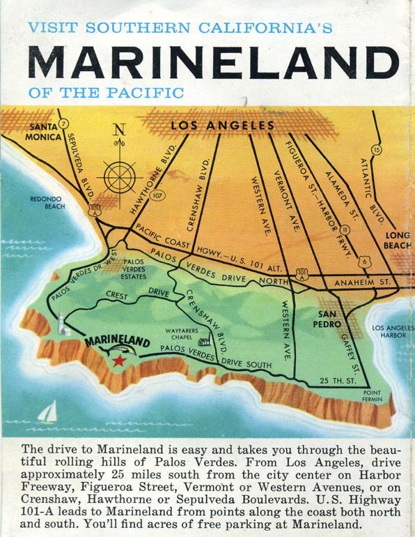
Marineland 1959 brochure with directions .Note that the map above does not have any freeways, which had not yet been built!
While collecting the thousands of animals to stock Marineland, teams pioneered techniques and invented devices still used today, such as transport tanks, the hoop net, the sea life decompression chamber and the slurp gun.
Early brochures
By opening day, the $3 million oceanarium had assembled the nation’s largest collection of marine life — sea turtles, moray eels, sawfish, sea anemones — and brought in more than 14,000 patrons.
Postcard of Marineland (note pier in background)
But ticket sales leveled off too soon, and by 1956 the owners decided to recreate the oceanarium as an ocean-themed entertainment park.
In 1957, they caught Bubbles, a 12-foot-long, 1,600-pound female pilot whale — the first ever caught and kept alive in captivity.Ticket sales went through the roof,Bubbles became an international superstar. The media went wild.
Bubbles the whale
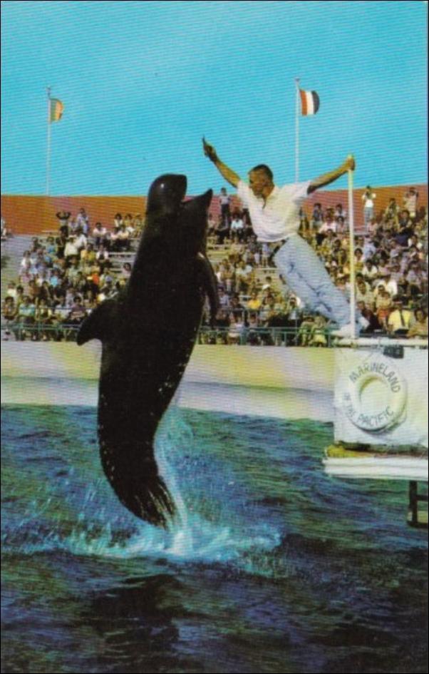
The craze boosted ticket sales past 1 million that year, which allowed owners to build a $500,000 sea lion and dolphin stadium in 1958. Bubbles was eventually joined by other pilot whales named Squirt and Bimbo, who jumped and dived and sprayed for their cheering fans.
Sea Hunt, a television series which ran from 1958 to 1961 starring Lloyd Bridges as Mike Nelson was initially filmed primarily at Marineland, and in fact, the show’s character Mike Nelson was an ex-Navy frogman employed by Marineland, until later in the show he had adventures from his ship called the Argonaut. This show expanded the fame and popularity of Marineland.
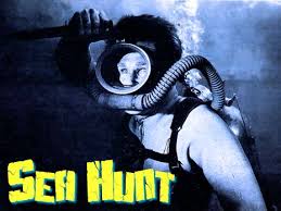
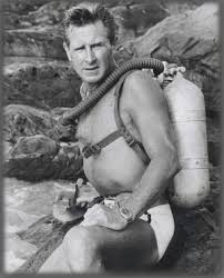
Sea Hunt Star Lloyd Bridges at Marineland
In early 1961, Marineland launched a far-reaching, $20,000 expedition to the Bering Sea and added four baby walruses to its menagerie. By 1965, the not-so-little ones outgrew their habitat, so park owners built them a new $250,000 one — known as the Walrus Waldorf.
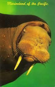
Woofy the Walrus
But over time, as Disneyland opened in 1955 and Sea World San Diego was built in 1964, the theme park competition took a toll on Marineland, and attendance plateaued. Still, park owners continued to add more new attractions. The Sky Tower was erected in 1966. The four-minute, 244-foot-high ride offered panoramic views of the Southern California coast.

The park got a boost in 1968 when it captured Orky, its first killer whale, who was soon joined by Corky. The popularity of the black-and-white duo bumped Bubbles and her crew from the largest, top-deck stadium.
But by the early 1970s, the competition was getting more and more fierce, and ticket sales were dwindling. Marineland’s original shareholders restructured Oceanarium Inc. as Marineland of the Pacific, Inc. and brought in 20th Century Fox as park operators.The park was then sold in 1978 to the owners of Hollywood Park in Inglewood.
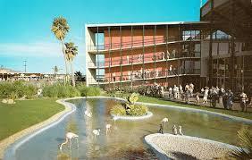
Penquins and flamingos at Marineland
20th Century Fox soon pulled out as operator of the park, and Hollywood Park brought in Hanna-Barberra as park operator. Hanna-Barbera costumed characters are seen, including Scooby-Doo, Huckleberry Hound and Yogi Bear, and the Baja Reef attractionwas built,but later investment and new attractions were minimal and the park’s heyday had passed. Not even the Great American High Diving Team, which performed in the sea arena during the 1970s, could boost ticket sales.
Vintage postcard of the Sea Arena at Marineland
The enactment of the Marine Protection Act of 1972 also made it illegal to capture any new animals from the wild, so the park and others like it expanded their breeding programs.
Click here to view some photos of the ‘Marineland Remembered’ exhibit at PVIC
In the late 1970s and early ’80s, the park added more visitor-participation attractions, such as snorkeling in the giant fish tank, playing catch with the dolphins and handling critters in the touch tanks.
Eventually, the costs associated with the park’s breeding program and marine animal-care center were outweighing ticket sales. Expansion plans were discouraged by the California Coastal Commission and the city of Rancho Palos Verdes, which was worried about increased traffic.
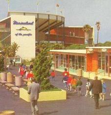
Entrance to Marineland of the Pacific
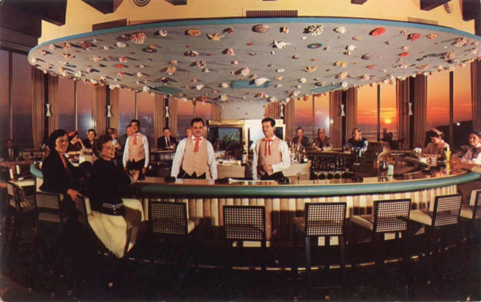
Marineland Restaurant Cocktail Lounge
Marineland closed in December1986 when Harcourt Brace Jovanovich, which owned Sea World in San Diego, purchased Marineland, ostensibly to continue to operate it. Their intent, however, was to purchase Marineland solely to acquire Corky and Orky, a successful breeding pair of killer whales.
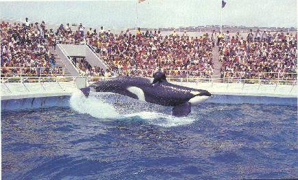
Orky, the larger male, at Marineland show
Harcourt was in the process of rapidly expanding the Sea World enterprise throughout the nation, and was in desperate need of proven, successful breeding pairs of killer whales in order to supply their new Sea World locations with their headline act, “Shamu, the killer whale”. Harcourt had been denied a permit to capture additional killer whales in the wild and was therefor limited to acquiring killer whales already in captivity. They therefor purchased the park, and within a few weeks after the purchase, moved Corky and Orky to their Sea World Park in San Diego in the middle of the night without any prior notice to the public, and closed Marineland claiming that the park was going to cost more money to renovate than they originally estimated. They had planned to sell the land to an Arizona developer from the beginning, and quickly did so after closing the park. Unfortunately, Orky, the male, died two years later in 1988, however Corky is still alive (she is now believed to be about 40 years old and the oldest of the seven killer whales in San Diego)and performing daily at Sea World in San Diego. She gave birth to seven calves, however all died soon after birth, with the oldest living only for 46 days.
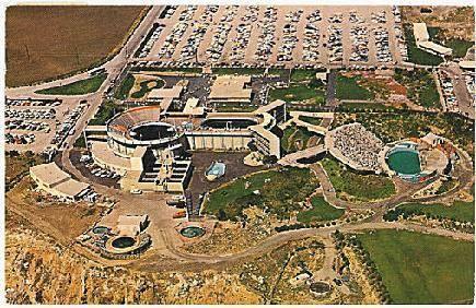
Aerial view of Marineland attractions
In a prenegotiated transaction,immediately after closing the park, Harcourt sold the park to a developer from Arizona, who planned to develop the park into a large hotel development. After many years, however, the loan which a Savings and Loan had made to the developer was foreclosed on, and a group of investors, headed up by James York,acquired the property.The large fiberglass figure of Bubbles, the pilot whale, anda fiberglass killer whale, that used to adorn the entrance sign to Marineland, are still stowed in a storage yard at the Rancho Palos Verdes City Hall facility.
Postcard of Marineland entrance, with fiberglass models of Bubbles the pilot whale and killer whales
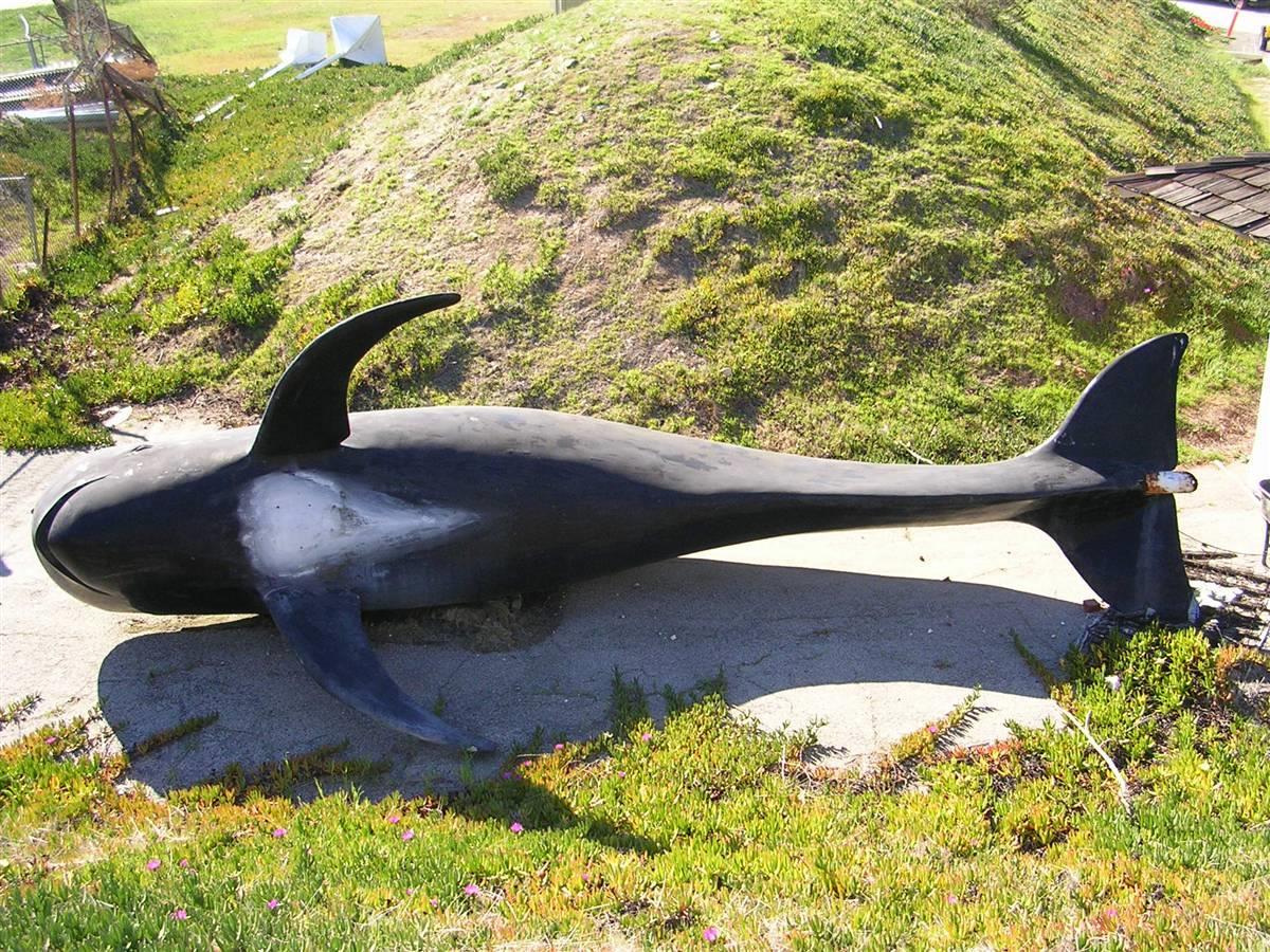
Bubbles the whale in Storage at Rancho Palos Verdes City Hall Photo by Bruce Megowan
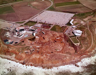
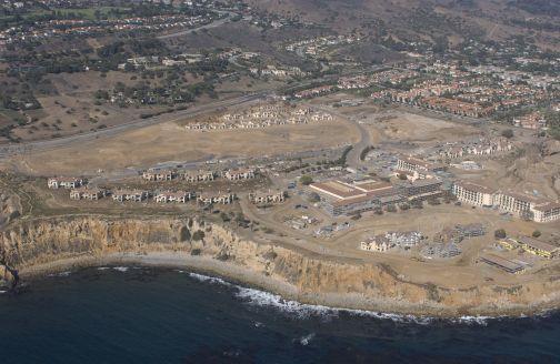
Jim York’s investor group, and their partner Lowe Enterprises attempted for several years to plan an 18 golf course utilizing not only the previous Marineland Property, but also city owned land surrounding the city hall, as well as land currently used as homesites for the Oceanfront Estates project where Hawthorne ends at the ocean. The owners of the Oceanfront Estates project finally decided not to include their development around the proposed golf course. Lowe Enterprises continued to attempt to utilize the Marineland property and the city owned land alone for an 18 hole golf course, in addition to their plans for a resort development, but finally the city rejected the use of city owned land for a golf course. Lowe Enterprises, through a subsidiary Destination Resorts, constructed a $250-million resort there, named Terranea, with construction started in 2006. Completed and opened in mid 2009 it includes a 400-room main hotel, flanked by 50 casitas and 32 resort villas, a world class 25,000 sq. ft. spa, a 60,000 sq. ft. banquet and conference center, as well as an executive 9 hole golf course.The last of the ruins of Marineland were demolished in the summer of 2006.
Terranea under construction (photo courtesy of California Coastal Records Project
Peninsula residents to this day, however, still miss Marineland, Corky and Orky, Bubbles the pilot whale, and the porpoise show.
Portuguest Bend and The Portuguese Bend Club
The Portuguese Bend area has an interesting history. Portuguese Bend was named for Portuguese whalers who used the cove for a rendezvous and a whaling station. Portuguese Bend was also a smuggler’s hideaway.
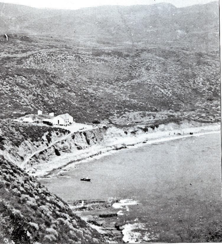
A Scandanavian fisherman named Charles Lundquest lived in this home in Portuguese Bend around 1900 , and cooked seafood dinners for 25 cents for yachtmen and excursion boats from Long Beach. that charged $1.50 roundtrip including the dinner.. This photo was taken in 1909, courtesy of the Palos Verdes Library .
From 1945 to 1956, until a major land slide occurred in the area (described below),the Livingston Quarry operated, mining such minerals as barite, quartz, dolomite, gypsum, as well as basalt that was mined for use as a railroad bed material. The Livingston Quarry area can be viewed by turning on Forrestal Drive, across the street from Trump National Golf Club off of Palos Verdes Drive South, and driving past the Ladera Linda Community Center and past the gate. This area is part of the Forrestal Preserve area, which was purchased as a nature preserve in 1996.
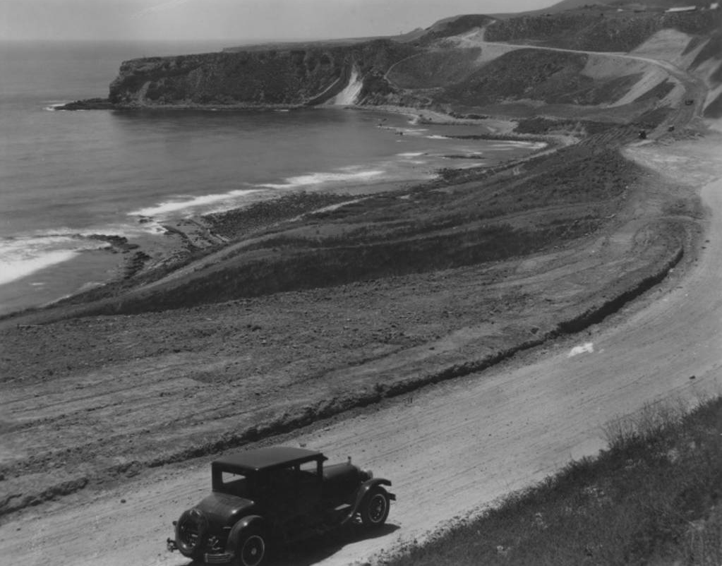
Palos Verdes Drive South – Portuguese Bend – 1928
The Portuguese Bend Club is a private beach colony that has existed since the 1940s. Now, there are 94 homes there and their occupants live alongside a landslide that presents a tolerable amount of inconvenience.
Covering 38 acres with a half mile of coastline, this area was once a haven of summer cottages and small homes built on land leased from Palos Verdes Properties. They were the typical 1940s weekend places where people went to have a quiet time at the beach. Back then there was a clubhouse, restaurant, paddle tennis courts, 50 foot swimming pool, a sandy beach, and a 485 foot long dockwhere boats could tie up. The restaurant, dock and clubhouse are gone and have been replaced with a volleyball court, playground equipment and, of course, the clubs signature palm thatched ramadas and picnic tables. See the following video with delightful pictures of the Club during the 1940’s and 1950’s: Vintage Portuguese Bend Club.
Portuguese Bend Club before Landslide.Kelly-Holiday Photography. (LAPublic LibraryPhotos). Note “PBC” in plants on hillside on right.
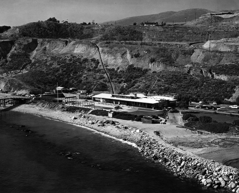
Portuguese Bend Club before Landslide.Kelly-Holiday Photography. (LAPublic LibraryPhotos).
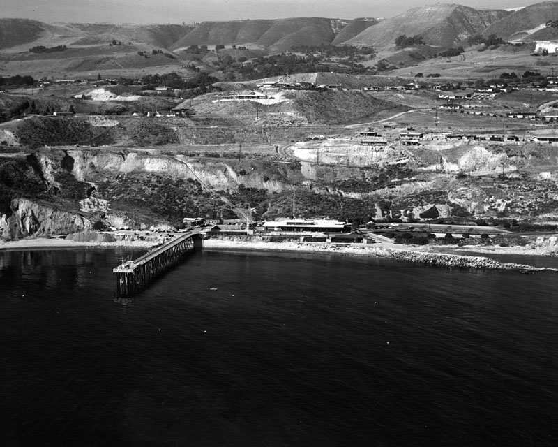
Portuguese Bend area before landslide. Note Portuguese Bend Club and Pier in upper left Kelly-Holiday Photography. (LA Public Library Photos)
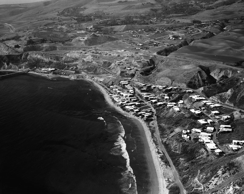
Aerial photo of Portuguese Bend club today after landslide. Note the many homes destroyed at the Portuguese Bend Club as well as the Portuguese Bend Club itself
The leases on the cottages were short, only twenty-five years, because Palos Verdes Properties was not sure what they wanted to do with the property. Then in 1956 a 260 acre landslide started and dramatically changed any plans that may have existed. The land slide was triggered by roadwork by L.A. County road crews who were constructing an extension of Crenshaw Blvd. from Crest Road, through Portuguese Bend, to Palos Verdes Drive West. Approx. 235,000 tons of dirt which had been excavated for the road had been relocatedto the top of an ancient, but previously dormant land slide. In August, 1956, the landslide broke a water line, and significant land movement began. A number of homes began to slide and some of the roads had to be re-routed. Some residents gave up and saw their homes go into the ocean; others left the area. Approx. 100 homes were destroyed, and more than 50 damaged, and the Portuguese Bend club house, restaurant, and pool were destroyed.
Portuguese Bend Landslide area, with Livingston Quarry at Ladera Linda in upper right
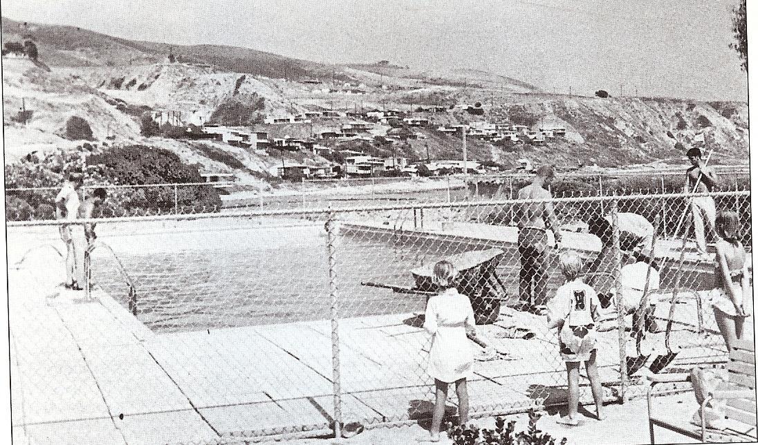
Portuguese Bend Club pool
The land in this area has moved more than 400 feet seaward, and continues to creep towards the ocean to this day, requiring constant repair and maintenance by the City of Rancho Palos Verdes. A significant amount of the City’s annual road maintenance budget is spent on this work. A building moratorium still exists in the landslide area. Several homes continue to be occupied in the land slide area, with the homeowners constantly leveling their home due to land movement by the use of hydraulic jacks.
On ctober 1, 2008, the State Appeals Court reversed a lower court decision and decided that the Land Slide building moratorium ordinance of the City of Rancho Palos Verdes for the Portuguese Bend area constituted an unconstitutional “taking” of property, and that the City should issue building permits to property owners wishing to build homes in the area.”A permanent ban on home construction cannot be based merely on a fear of personal injury or significant property damage,” the jurist concluded, and ordered the case remanded for further proceedings to determine an appropriate remedy.
On October 8th, 2008, the City Council decided to appeal this decision to the State Supreme Court.On Wednesday December 17th, 2008, the California State Supreme Court denied the City of Rancho Palos Verdes appeal of the Appelate Court’s decision allowing homeowners in the Portuguest Bend landslide moratorium zones the right to develop their properties.
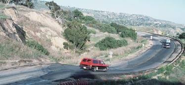
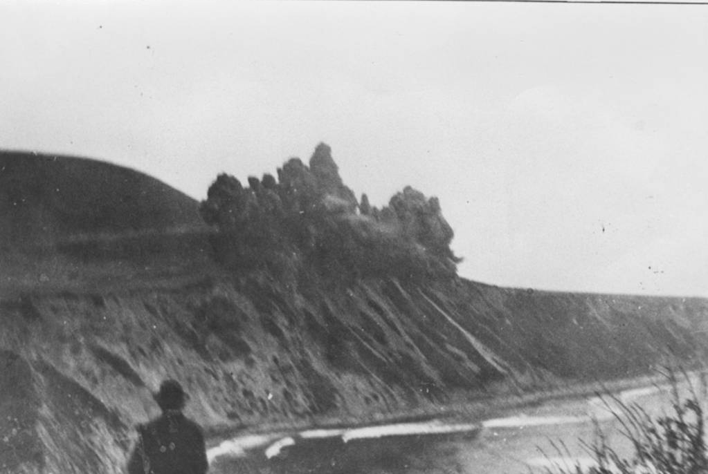
“Ski Jump” at the Portuguese Bend Land Slide
In the late 1950s Palos Verdes Properties put 42 lots up for sale and they were offered to people who had lost their homes in the slide. Lot numbers were drawn from a hat, with lots priced from $4,000 to$10,000. Some of the buyers moved their houses from the slide area; others built new ones. Beginning in the early 1970s leases on the properties owned by Palos Verdes Properties began to expire and the company started to raise the rent. Then in 1975 the residents of the club united to negotiate the purchase of their properties. These negotiations went on for the next twelve years and by then, Portuguese Bend was owned by the Transamerica Corporation.
Purchase of the individual properties from Transamerica was finalized in 1987. At that time there were 51 beachfront homes and their owners bought their cottage sites, the beach, the common area which included 19 acres, the gatehouse and the roads. No parcel map of the area existed then, only a tax assessors map, and property was bought on the basis of what you see is what you get. It wasnt until after the purchase from Transamerica that a survey was conducted to establish lot lines. Until recently, homes in the club were on septic tanks, but because the area is so close to the Portuguese Bend slide, City geologists, including the late Dr. Perry Ehlig, recommended that sewers be installed. Now, all of the homes are hooked up to a private system and it has its own sewer pumps and lines.
Transamerica retained a 19-acre area that stretched from the gatehouse down to the first house on Yacht Harbor Drive and, as recently as the early 1990’s, they planned to construct homes there. The property, however, was subsequently purchased by one of the residents and now a home is under construction at that site.
The Portuguese Bend club offers year-round membership to about 300 Peninsula residents. With membership comes the use of the beach and all of its facilities-paddle tennis courts and volleyball courts-on a year-round basis. The beach also attracts a breakfast, brunch and dinner crowd; it depends on the time of year and, of course, the weather.
Now that the sewer system is installed and, if the landslide continues to hold to its boundaries, the residents hope to continue improving the beach and making it available to more members so they can experience life at the beach in RPV.
Don Wallace and W6AM
Don Wallace, a ham radio pioneer who worked as an amateur radio operator since 1913, operated W6AM as a ham radio operation from his land atop the Palos Verdes Peninsula at the junction of Armaga Springs road and Highridge road. His antennae farm included a huge installation of rhombics antennas each perched upon telephone poles, some over 150 feet tall. The site was originally acquired in the 1930’s by Press-Wireless, owned by a group of newspapers to receive news dispatches from around the world. During WW II, the War Department used the facilities to communicate with battle operations in the Pacific, relayed to Pearl Harbor. In 1945, Don Wallace bought the land from Kelvin Vanderlip who, in order to control deed restrictions, had bought the land from Press-Wireless.
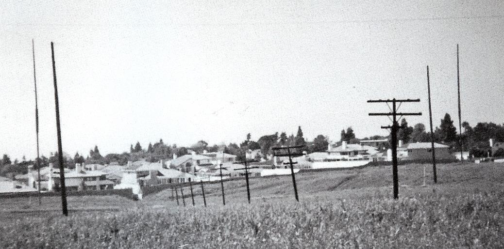
Wallace Ranch Antennae Farm
The station in 1945 had 120 acres of land with 16 rhombics, the longest being 1500 feet (end to end). This 1500 foot rhombic is widely believed to have been the largest beam antenna ever in amateur service. He had 61 telephone poles, each at 80 feet and another 90 feed line poles (25 feet high each). These antennas were fed by 52 MILES of feed lines.
In 1942, William Arthur Schuler, 23, who lived in Palos Verdes Estates and worked for Press-Wireless, was arrested by the FBI for spying.l He had offered to transmit messages to foreign agents using the Press-Wireless transmitters. He got six years in the federal penitentiary.
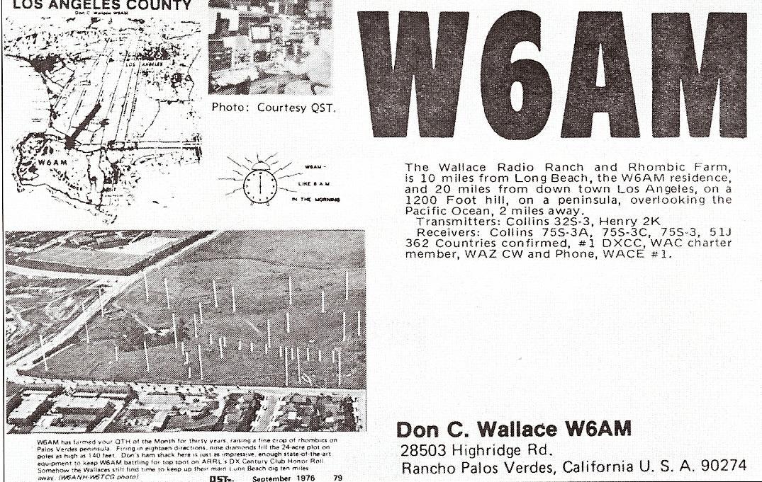
In 1962, Don had to sell 95 of the acres (to pay the property taxes) and he collected the grand sum of $100K for the 95 acres. Don then consolidated his antennas. He installed ten 140 foot poles on the perimeter of his remaining 25 acres with rhombics layered every 6 feet in various directions with rhombics beginning at the 90 foot level and going in layers of 6 feet up to 140 feet high.. Height of the rhombics varied from 100 to 140 ft. In the late 60’s or so. Don operated his array up until he died in 1985.
Don Wallace also operated his ham radio from his car.
The land which Mr. Wallace owned is today several condominium and luxury home developments including The Wallace Ranch.
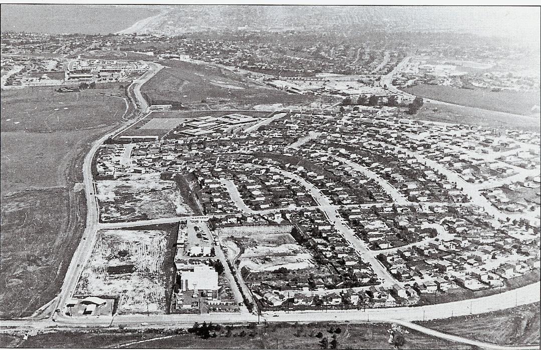
Late 1960’s view of Intersection of Crest Road and Highridge road with Wallace Antennae Farm on left. The home development on the right was constructed in the mid and latte 1960’s when plans for Palos Verdes State College were abandoned in favor of the current location of California State University at Dominquez.
Eastview:
In 1983 the unincorporated area of Eastview was annexed to the City of Rancho Palos Verdes, but there were no changes made to school district boundaries and Eastview remained in the Los Angeles Unified School District. During the years 1983, through at least 1995, the LAUSD opposed all attempts of the PVPUSD to revise its District boundaries to include Eastview. In 1991 the entire Board of Education for PVPUSD signed Resolution 16 supporting the territory transfer for the Eastview area from LAUSD to PVPUSD. PVPUSD was successful in using the school district reorganization process that included an election where 84% of the Eastview residents approved the transfer. However, the process failed when the courts determined that the election was invalid since it did not include residents of the LAUSD. Ultimately,SB 1681 made Eastview an optional attendance area in 1999.
Those students who live in the Eastview area have a one-time election to enroll in either the Palos Verdes School District ( attending Dapplygray Elementary and Miraleste Intermediate ) , or the Los Angeles Unified School District ( Dodson Middle School and Crestwood Elementary School). Those living in the Eastview area do not pay the bonded indebtedness on their property tax bills ( 2009/2010 of $21.64 per $100,000 valuation ) for the Palos Verdes School District, but instead are billed for the Los Angeles Unified School District bonded indebtedness on their property tax bills (2009/2010 of $151 per $100,000 valuation ). Eastview residents vote only on School Board elections for Los Angeles Unified Schools regardless of whether they have elected to attend the Palos Verdes School District.
Rancho Palos Verdes Ecological Reserves
The founding of the City of Rancho Palos Verdes was predicated on preserving the natural and open areas of the Palos Verdes Peninsula to as large an extent as possible. The Palos Verdes Peninsula Land Conservancy whose mission is “Preserving land and restoring habitat for the enjoyment and education of all”, was founded in 1988 and has led the way in acquiring and protecting approx. 1,800 acres of land on the Palos Verdes Peninsula. In December 2009, the Convservancy led the way in acquiring the last available large open space parcel, an approx. 190 acre parcel from James York, a local real estate investor. This parcel, known as the Upper Filiorium property, was the “missing link” in connecting the Portuguese Bend Nature Preserve to the Three Sisters Preserve, creating one lage contiguous preserve area.
![[rancho+palos+verdes+ecological+reserves.jpg]](https://www.maureenmegowan.com/wp-content/uploads/2019/01/eg0IUXIYnrNFOy_oSMY1EPI3ctOtMA8zQFZ-g_xZtZezXnXDRxNvtGozanoqiEk44a5Edo9jQzOjzo-XMmPzBfVzE19zv2hCZ0SDOVjGQcKeOKbq74JcJc1g6zgLh2DPEDgX3p7j)
Rancho Palos Verdes Nature Preserves before Upper Filiorium property acquisition in 2009
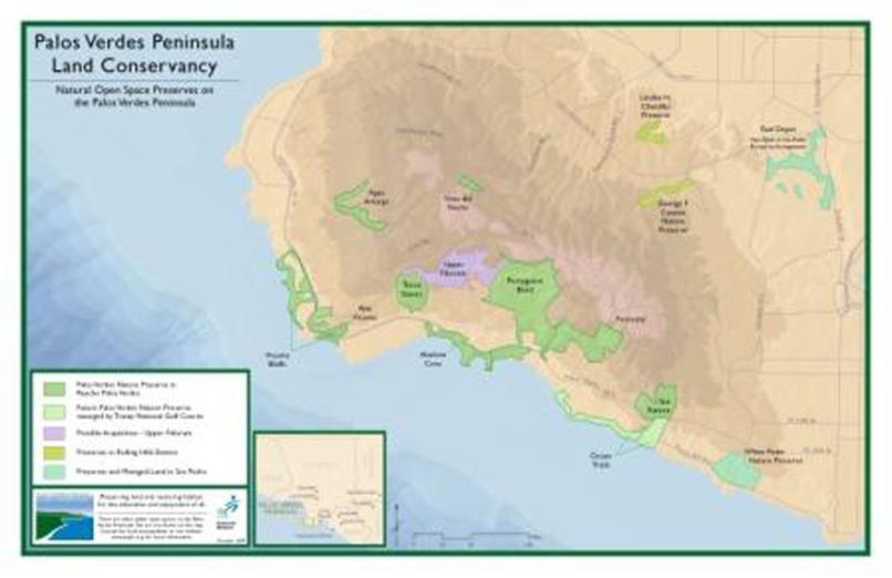
Nature Preserve Areas in Rancho Palos Verdes including Upper Filiorium Property ( in purple )
Trump National Golf Course
In the 1950’s, Edward Zuckerman, with a partner, purchased a sloping 150 acre garbanzo bean field rising up from the cliffs of the ocean. In 1970, Ken Zuckerman’s father had tried to build on his farmland 1,200 apartment units, a 200-room resort hotel, and a nine-hole golf course. As noted above, this massive planned development prompted the formation of the City of Rancho Palos Verdes. The new government placed a moratorium on development, then downzoned the Zuckerman’s property to require that all new homes be built on one-acre lots. Based on these restrictions, it didn’t make sense to build, so the Zuckerman’s sat on their property until 1989, when Ed Zuckerman’s sons, Ken and Bob, with a partner,formed a joint venture for an additional 100 acres from developer Barry Hon to accumulate a total of approx. 260 acres, with close to two miles of ocean frontage.
The Zuckerman family spent years working with the City of Rancho Palos Verdes and various environmental groups to create a plan which would provide native sagebrush habitat for a rare bird, the California gnat-catcher. The plan was initially approved in 1994, however construction was delayed by years of lawsuits by environmental groups. The Zuckerman brothers created a new limited partnership in 1997, buying out Barry Hon. Development finally began in 1998. Ultimately, out of the Zuckerman’s 260 acres, 75 were devoted to 75 home sites. The golf course is built on 100 acres (compared with 150 for a typical course), but 20 of those were required to be covered with regrown sagebrush. The California Coastal Commission also required public access to the cliff side areas by public access pathways. So, 105 acres were reserved for sagebrush, public parks, or pathways.The effects of providing the native sagebrush habitat can also be seen in the difficulty of the golf course. The sagebrush grown between fairways to benefit the gnatcatcher makes it easy for the amateur player to lose golf balls. On the day of the landslide, the U.S. Golf Association was giving the Pete Dye designed Ocean Trails a course rating. The preliminary “slope” rating, which indicates how hard the course is for a bogey golfer, was 154, just under the maximum limit of 155 (The current slope rating, after recent modifications to the course, ranges from 133 to 142).
Unfortunately, on June 2, 1999, just before its scheduled July 2nd opening, a large portion (approx. 17 acres) of the cliff-top 18th fairway slipped towards the ocean creating a huge chasm. The project, which had been originally budgeted for $126 million, required another $61 million to repair the land slide damage (paid for by insurance proceeds). For months, the course operated on a temporary basis as a 15 hole course.
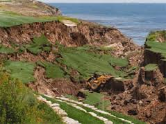
The property was then tied up in various lawsuits, including a claim by Zuckerman that a water line running under the property had burst, causing the land slide, however another potential cause was discovered, that an ancient landslide, previously undetected,may have been the cause of the land slide. Ultimately, the Zuckerman’s were forced to declare bankruptcy, and the property was taken over by Credit Suisse , the lender on the property, in February 2002. In August 2002, Donald Trump acquired the Ocean Trails project for a reported $27 million. Subsequently, Trump has completed the repairs of the 18th fairway, widened the fairways, remodeled the club house, constructed two water falls on the 1st and 17th greens, and constructed a driving range, reducing the number of lots to be developed as homes. Approx. 36 home sites are currently planned, and Trump is attempting to get approval for up to 150 additional casitas, however this plan has been met with skepticism by the Rancho Palos Verdes city council. The course finally opened as an 18 hole course on January 20, 2006. Including the money Trump has invested in the course and the original investment by the Zuckerman family, the project has expended in excess of a reported $300 million, clearly making the course the most expensive golf course ever constructed.
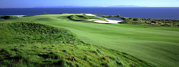
Wayfarers’ Chapel
One of the most notable landmarks in Rancho Palos Verdes is the Wayfarers’ Chapel located near Portuguese Bend. This “Glass Church” was built by the Churches of the New Jerusalem in 1951 as a national monument to Emanuel Swedenborg, an eighteenth-century mystic. The construction was made possible by Mrs. Narcissa Vanderlip, who donated the site, and was designed by Lloyd Wright, son of Frank Lloyed Wright.
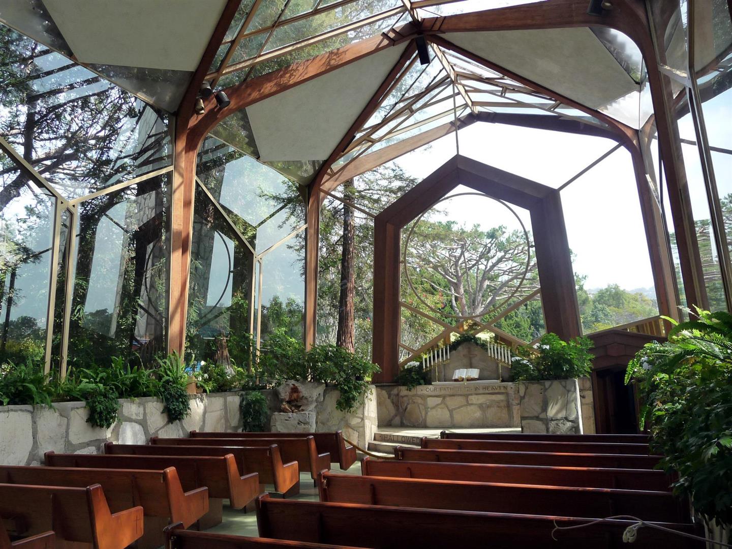
For an extensive photo history of the Palos Verdes Peninsula, go to http://www.flickr.com/photos/pvlocalhistory/show/
See the Palos Verdes Peninsula News Article on Maureen Megowan’s Historical Web Pages
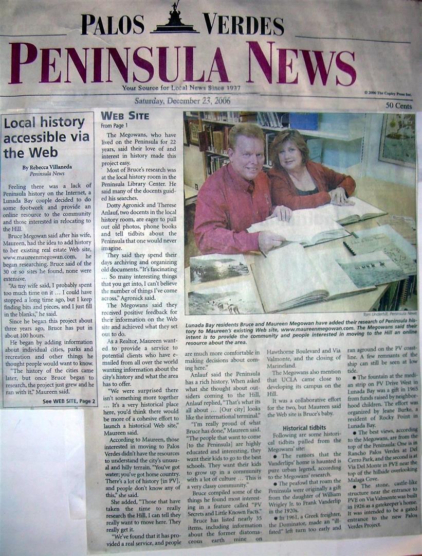
Click on the following links for the history of individual cities in the South Bay Los Angeles beach communities:
HISTORY OF PALOS VERDES ESTATES
HISTORY OF RANCHO PALOS VERDES
HISTORY OF ROLLING HILLS ESTATES AND ROLLING HILLS
COPYRIGHT NOTICE:
Graphics, content and html coding may not be reproduced or copied in any way with out written permission from Maureen Megowan All html coding, layout and original content and graphics are copyrighted – Maureen Megowan and may not be used, copied or reproduced on another web site. Maureen Megowan makes no guarantees or warranties as to the information provided herein.
Sources:
Historical photos courtesy of the Palos Verdes Library, the Los Angeles Public Library , and The Palos Verdes Story, by Delane Morgan
The Palos Verdes Ranch Project, by Thomas Gates, Kent State University
History of the Palos Verdes schools by Rosemary Claire and Jim Kinney, formerly PVUSD
Marineland of the Pacific Information and photos:
http://www.marinelandofthepacific.org/pages/1/
http://forums.whale-web.com/showflat.php?Cat=&Number=131796&Main=131796
“Palos Verdes Peninsula: Time and the Terraced Land”, by Augusta Fran
The Peacocks of Palos Verdes by Mary Jo Hazard
“Eccentric Obstinate and Fabulous!”, memoirs of Elin Vanderlip
Rancho Palos Verdes, Images of America, Ginger Garnett Clark
I am indebteded to Delane Morgan, author of The Palos Verdes Story, and many excerpts from her excellent History of Palos Verdes have been included above. I would highly recommend purchasing her book, which includes numerous historical photos and a much more detailed history of the Palos Verdes Peninsula. This book may be purchased at the shop Nantucket Crossing located in the Town & Country Shopping Center on Silver Spur Road in Rolling Hills Estates.