History of San Pedro
Portuguese explorer, Juan Rodriguez Cabrillo, while sailing under the flag of Spain, was the first European to set eyes upon the barren hills and plains of what was to be Rancho San Pedro. On October 8, 1542 he sailed into San Pedro Bay. There, he noticed several wild fires burning in the surrounding hills producing dark plumes of smoke. He named the area “Bahia de los Fumos” which was Spanish for “Bay of Smokes”. This bay with a shallow estuary held this title for over fifty years, until changed by another Spanish sea faring explorer. On November 26, 1602, Sebastian Viscaino sailed into the same bay and renamed it Ensenada de San Andres (Bay of Saint Andrew), mistakenly thinking he arrived on the feast day of Saint Andrew. In actuality he entered the bay on the feast day of Saint Peter, Bishop of Alexandria. In 1734, Cabrera Bueno, a famed navigator and cosmologist discovered Vizcaino’s error and renamed the bay San Pedro, in honor of the martyred saint. Today, the port community of San Pedro still retains the name.
The site, at the southern end of the Palos Verdes Peninsula, on the west side of San Pedro Bay, was used by Spanishships starting in the 1540s. The vessels that traded at San Pedro anchored at a point on the northwest side of San Pedro, slightly northeast of Point Fermin, off the coast of Rancho Palos Verdes. Though later known as Timms’ Point, this anchorage was first called Sepulveda Landing.
Regular settlement began in 1769 as part of the effort to populate California, although trade restrictions encouraged more smuggling than regular business. When Mexico won its independence, the trade restriction were lifted, and the town flourished
Mexican governor Fages bestowed a provisional grant to Juan Jose Dominquez, a member of the 1769 Spanish Portola Expedition to Alta, Californian, in March 1784, allowing him to graze his cattle on 75,000 acre Rancho San Pedro. This was the first private land grant in Southern California. Rancho San Pedro stretched from Compton to Redondo Beach to Long Beach, and included the Palos Verdes Peninsula and, of course, San Pedro. Juan Capistrano Sepulveda and Jose Loreto Sepulveda, the two eldest sons of Don Jose Sepulveda, in 1834 were granted a judicial decree by Governor Jose Figueroa of 31,600 acres of Rancho San Pedro to the Sepulvedas (including the town of San Pedro), which was intended to settle the dispute between the Dominquez and Sepulveda families. (See the History of the South Bay for a discussion of the early Spanish land grants).
By 1835, San Pedro had become the most important port on the Pacific Coast. Because of shallow water and mud flats, ships had to drop anchor about a mile off shore, and small boats would then transfer passengers and cargo ashore. These would often capsize, spilling both passengers and cargo into the muddy water. During this time, the Sepulvedas built a crude dock and landing at the base of cliffs near present day Fourteenth and Beacon Streets in San Pedro, which became known as Sepulveda Landing. Two major geographical features of San Pedro Harbor at this time was Deadman’s Island (which was later dredged and became part of the current breakwater) and Rattlesnake Island (which later became Terminal Island.
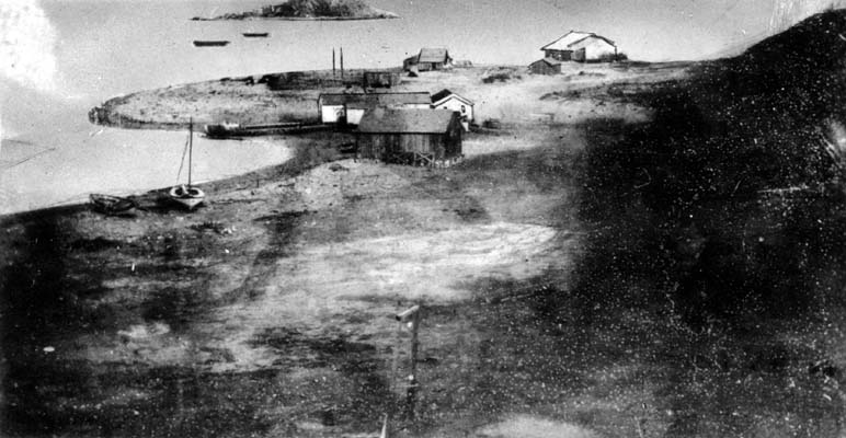
San Pedro in 1850, Dead Man’s Island in the background (source: http://waterandpower.org/museum/Early_Views_of_San_Pedro_and_Wilmington.html LA Public Library photo)
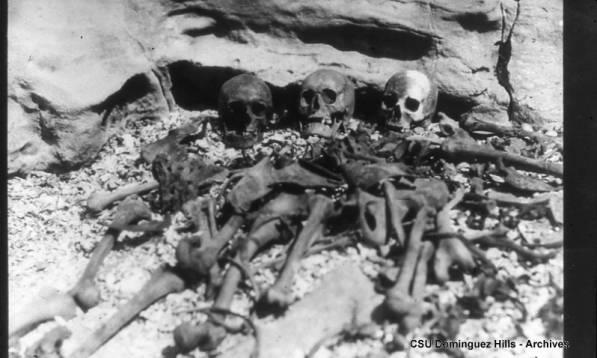
Bones discovered on Deadman’s Island during the removal of the Island for the construction of the San Pedro breakwater. Photo dated 1928, courtesy of California University Dominquez Hills archives
In 1851, 21 year old Phineas Banning arrived in San Pedro from Philadelphia. Banning, and his partner, George Alexander, soon began operating a stagecoach service from San Pedro. When August Timms bought the Sepulveda Landing, early in 1852, Banning was concerned (Sepulveda Landing then became known as “Timms Landing”).
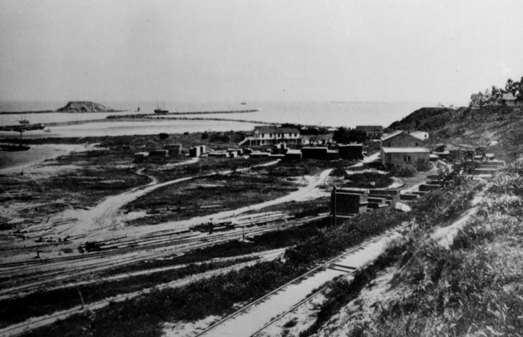
1870’s View of Timms’ Point, Los Angeles Harbor. Breakwaters and Deadman’s Island can be seen in the background. http://waterandpower.org/museum/Early_Views_of_San_Pedro_and_Wilmington.html LA Public Library photo
When word came from Washington that San Pedro would soon be declared an official port of entry with its own customhouse, Banning negotiated to buy a tract of land from the Sepulvedas, located near Timm’s Landing, and promptly built his own wharf. In November 1854, Banning and a group of investors (J.G Downey, Don Benito Wilson, and William Sanford) purchased 2,400 acres adjacent to San Pedro, for port expansion. This land later became the city of Wilmington, after Banning’s Delaware birthplace.
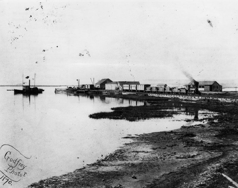
Bannings Landing, Wilmington, 1870
Source: http://waterandpower.org/museum/Early_Views_of_San_Pedro_and_Wilmington.html LA Public Library photo
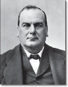
Phineas Banning, 1883
The military has had a long history in San Pedro. Camp Drum was established as a five company post originally named Camp San Pedro in January 1862, and located one mile from Wilmington, now a part of Los Angeles, on land donated by Phineas Banning. This post until 1 December 1863 called itself Camp Drum; it was thereafter designated as Drum Barracks. It was named by the War Department in honor of Lieutenant Colonel Richard Drum, assistant adjutant general of the Department of California.
Drum Barracks was a footnote in U.S. Military History when it participated in the grand experiment of utilizing camels in troop movements. In 1863, Major Clarence E. Bennett, post commander, complained, “They had been kept at this post a long time on forage when in San Bernardino and various places within 100 miles of here they could have been subsisted without the expenditure of one cent for forage.” He recommended the 36 camels at Drum be tested for service across Mojave Desert and be shipped to Fort Mojave because almost all grass at Drum was gone “and in little time the plains formiles and miles here will be perfectly bare.” He advised they be carefully trained and tended by “an energetic officer whose conduct was characterized by sobriety and integrity.- He blamed failure of previous camel use on fact government employees “regard service with camels extremely unpleasant.” He said, “In appearance camels are extremely ugly, in gait very rough, in herding inclined to wander, and with their long strides they make haste slowly, keeping their herders on the go; they offer no facilities for stealing.” The idea was not approved and camels were auctioned off at Benicia Depot the next year.
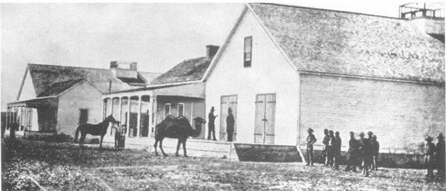
Camels at Drum Barracks
Source: http://waterandpower.org/museum/Early_Views_of_San_Pedro_and_Wilmington.html USC Digital Archive
In late 1870, the camp was officially abandoned. Only 90 men remained on the post whose structures were deteriorating rapidly. By 1871, all had left with their equipment and stores transferred to Fort Yuma. On July 31, 1873 the camps buildings were sold at an auction. Banning bought five of them for a sum of $2,917 with his business partner, D.B. Wilson, buying one for $200. The land was returned to Banning and Wilson. Drum Barracks lives today as the restored junior officers quarters. There is the powder magazine but it has deteriorated and is too far from the museum to be counted. The mansions 14 rooms contain Civil War artifacts, weapons, paintings of Barracks commanders, a library dedicated to the study of the Civil War and southern California history and several rooms laid out as they might have appeared during the period
In the late 1860’s Banning realized that for San Pedro Harbor to become a center of commerce, that three things needed to be accomplished: Building a railroad, constructing a break water, and dredging the harbor to accommodate large ships and to allow them to dock directly at the wharfs. In October 1869, construction was completed on the Los Angeles and San Pedro Railroad, Southern California’s first railroad. On March 2, 1871, Congress voted an appropriation for construction of a rock jetty from the lower end of Rattlesnake Island to Dead Man’s Island.
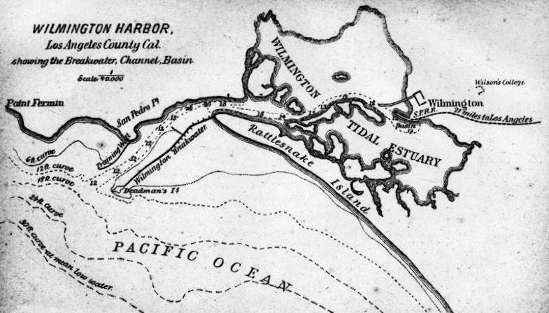
1880 Drawing of Wilmington Harbor, showing the breakwater, channel, basin and railroad tracks. Wilson’s College (top right) was established in 1874 and existed in the early 1880’s. Wilson College was a precursor to the University of Southern California. It opened in Wilmington in 1874 as the first coeducational college west of the Mississippi. Active for several years, it closed after the Methodist Church Conference received a large donation of land closer to Los Angeles and decided to develop on that site. Opened in 1880, that new college would become the University of Southern California.The next college to open in Wilmington was Los Angeles Harbor Junior College in 1949, an institution that became an important link in the state junior college system
Source: http://waterandpower.org/museum/Early_Views_of_San_Pedro_and_Wilmington.html LA Public Library photo
In 1872, the Southern Pacific Railroad agreed to run their railroad through Los Angeles and purchased the Los Angeles and San Pedro Railroad. In 1875, a competitive railroad, the Los Angeles and Independence Railroad, was constructed from Santa Monica to Los Angeles, with a 1,700 foot wharf. By 1877, however, the Southern Pacific, after drastically lowering rates, drove the new railroad into ruin, and purchased it for less than half of what it cost to build. In 1881, they built an extension of the Los Angeles and San Pedro railroad across the Wilmington Lagoon on pilings to a point near Timms Point, thus enabling direct railroad access to the deep water wharf. Phineas Banning died in 1882, but his dream of making San Pedro a major port of entry to the United States would soon be realized.
Soon, two new railroads entered the picture, competing with San Pedro as the dominant port for the Los Angeles area. The Sante Fe railroad constructed a wharf in Redondo Beach, which shipped a considerable amount of lumber from there. On April 13, 1892, the Dominguez heirs sold the Rattlesnake Island to a competing railroad, the Los Angeles and Terminal Island Railroad Company. Rattlesnake Island was known as such because it was home to a large population of rattlesnakes who migrated down the Los Angeles River. The named was changed to Terminal Island by the railroad company because of the terminus of the rail line established there.
In 1891, a survey had been commissioned as to a recommendation for the location for continued funding and construction of a deep water port for Southern California. This survey had recommended San Pedro as the desired location for the port. Collis P. Huntington, who now headed up the Southern Pacific Railroad, had become annoyed by the competition of the Los Angeles and Terminal Island Railroad, as well as the Sante Fe Railroad in Redondo Beach, so began a vigorous lobbying campaign to designate Santa Monica Bay for harbor development, since the Southern Pacific Railroad completely controlled this option. By 1893, Southern Pacific’s railroad extension and wharf in Santa Monica were in full operation.
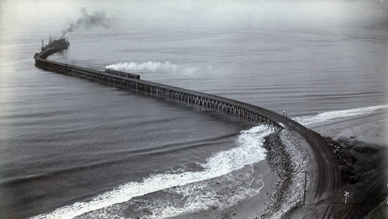
Santa Monica Long Wharf, at the time of construction, the world’s longest at 4,700 feet. Source: http://waterandpower.org/museum/Early_Views_of_San_Pedro_and_Wilmington.html LA Public Library photo
In 1896, an appropriations bill was approved by a congressional committee to fund the construction of a breakwater in Santa Monica, but an amendment was passed to the bill calling for a new commission to be appointed to review the best location for a deep water port. The Los Angeles Times publisher Harrison Gray Otis and U.S. Senator Stephen White pushed for federal support of the Port of Los Angeles at San Pedro Bay. The matter was settled when San Pedro was endorsed in 1897 by a commission headed by Rear Admiral John C. Walker . Finally in 1898, San Pedro was selected for the port improvements appropriation, and construction began on the new Federal breakwater project in San Pedro. This intense congressional battle was dubbed the “battle for a free port”, because it was feared that with the Southern Pacific’s monopoly of the Santa Monica port, that there would be no competition at the new port.

(ca. 1900)* – Panoramic early view of the Los Angeles Harbor at San Pedro circa 1900. Sailing ships are anchored at the wharf, and Dead Man’s Island is in the background.
Source: http://waterandpower.org/museum/Early_Views_of_San_Pedro_and_Wilmington.html LA Public Library photo
In 1888, the War Department took control of a tract of land next to the bay, and added to it in 1897 and 1910. This became Fort MacArthur in 1914, and was a coastal defense site for many years, which also included a Nike missile site in the White Point area. In 1978, the Secretary of the Interior transferred ownership of the White Point U.S. naval reservation to the City of Los Angeles to be used for recreational purposes.
Many other facilities were established in the San Pedro area, and it was a popular port of call for U.S. Navy ships. Construction of the breakwater began in 1899, with the first section completed in 1912. Subsequent extensions brought the breakwater to a length of 9 miles, with a 2,100 foot entrance. The City of Los Angeles was anxious to control the development of the improvements and operation of the Port of San Pedro, however could not annex either Wilmington or San Pedro unless they were contiguous to the City of Los Angeles. In 1906 the City of Los Angeles purchased a long narrow strip of land, a half-mile wide from Slauson Avenue, connecting the city to the cities of San Pedro and Wilmington (now known as the “Harbor Gateway” community). During the campaigning for approval of the annexation by the citizens of the two cities, Los Angeles agreed to make at least $10 million on harbor improvements within 10 years, and in 1909, the city annexed San Pedro and the adjacent town of Wilmington. The odd shape is still seen in the map of the city.
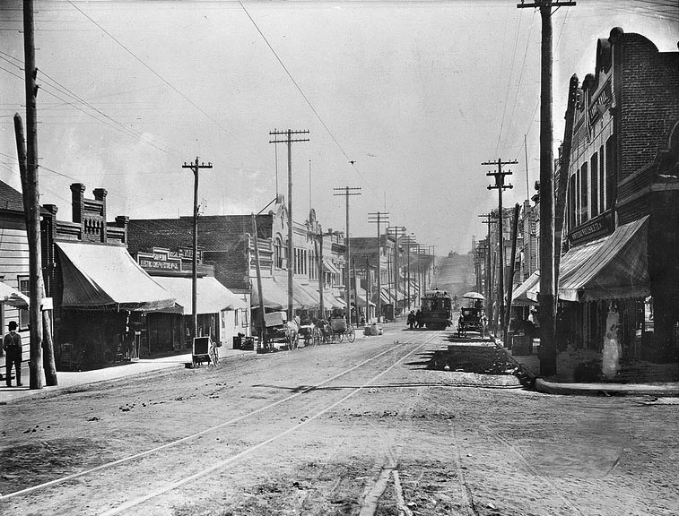
1903 Looking south on Beacon from Fifth Street circa 1903. Streetcar can be seen down the road.
Source: http://waterandpower.org/museum/Early_Views_of_San_Pedro_and_Wilmington.html USC Digital Archive
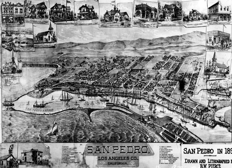
Map of San Pedro as it appeared in 1893. Drawn and lithographed by Bruce W. Pierce.Source: http://waterandpower.org/museum/Early_Views_of_San_Pedro_and_Wilmington.html LA Public Library photo
On December 9, 1907, the Los Angeles City Council created the Los Angeles Board of Harbor Commissioners, marking the official founding of the Port of Los Angeles. The first warehouse in the port was Warehouse No. 1 constructed in 1917.
Warehouse No. 1
In the early part of this century, the Port bustled with longshore gangs unloading millions of board feet of lumber for local construction projects. Thousands of commercial fishermen and workers in a dozen canneries were involved in catching and processing tuna. More than 20,000 ship builders were working in four yards on various cargo and tanker vessels. Busy and colorful commercial areas sprang up adjacent to the Port to accommodate these workers as well as the ship crews that would be in port of up to 10 days at a time.
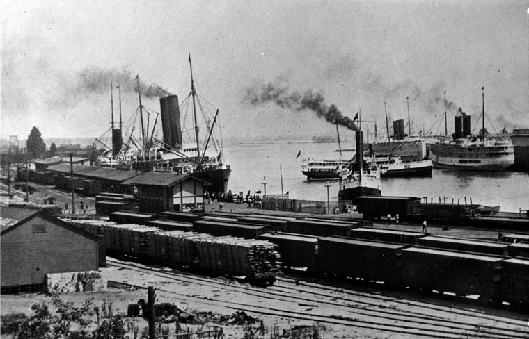
Port of Los Angeles in 1913 Source: http://waterandpower.org/museum/Early_Views_of_San_Pedro_and_Wilmington.html LA Public Library photo
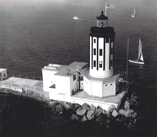
The Angel’s Gate Lighthouse has stood at the entrance to the port since 1913.
Between the turn of the 20th century and WWII, the White Point area of San Pedro was home to a thriving Japanese community of abalone fisherman and farmers. In 1899, 12 Japanese fisherman leased beach front property at White Point from Ramon Sepulveda, a descendant of Jose Dolores Sepulveda, the original Spanish land grant owner of San Pedro, with the intention of establishing an abalone and lobster fishery at that location. By 1903, they had earned enough money to construct a cannery at the fishery. This profitable industry ended in 1908 when it was alleged that these settlers were using fishing as a front for spying on coastline activities. Laws restricting how much shellfish could be taken were also enacted when the lobster and abalone population was quickly depleted.
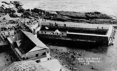
After the fishery closed, the area became a Japanese farming community and a resort locale. In 1915, Tojuro and Tamiji Tagami, with the help of Sepúlveda, developed the area as the White Point Health Resort, a sea side resort centered around a sulfur spring at the base of the cliffs. Tamiji suffered severely from arthritis but after several weeks of immersion in the hot water from the ocean, he recovered and was again able to work. So they built a bathhouse and then constructed the balance of the resort which consisted of a two story 50 room hotel and restaurant with a dance floor, three salt water plunges, an enclosed boating area, a bathhouse, and a pier which ferried tourists to a nearby fishing barge . Local children often bathed in the sulfur water on their way home from school. Doctor would send patients to the resort for the therapeutic powers of the hot springs, and tourists would stay there for the beauty of the weather and location.
Diver at White Point Resort
Various disasters in 1928 and the late ’30s, led to the decline and eventual closure of the property when storms damaged the pools and some of the buildings. In 1933, an earthquake sealed off the sulfur springs. Although the Tagamis continued to operate the hotel, they never actually owned the land. Ramon Sepulveda could not legally sell the land to Asian immigrants under a California law which prohibited ownership of land by those not eligible to become citizens. Although the hotel continued to operate despite these set-backs, the final blow came in the late 1930’s with the rise of anti-Japanese prejudice and depressed economic conditions forced the closure of the resort.
After the start of World War II, The federal government took over the area, becoming part of the nearby Fort MacArthur military complex. The resort’s buildings were demolished, and fortifications were added to the shoreline and nearby hillside.
The state of California bought the beach area in 1960, and it became Royal Palms State Beach. In 1995, the land was acquired by the county of Los Angeles and became Royal Palms County Beach
White Point Health Resort – Circa 1920’s
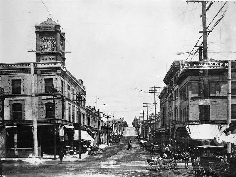
1910 view of Beacon Street in San Pedro looking north. Horse-drawn carriages can be seen throughout. A man crosses the street and walks towards the San Pedro Bank Building with its prominent clock tower. Source: http://waterandpower.org/museum/Early_Views_of_San_Pedro_and_Wilmington.html USC Digital Archive
In 1912, Wilbur Wood opened the California Tuna Canning Company at Los Angeles Harbor. Two years later, Frank Van Camp bought the company and renamed it Van Camp Sea Food Company. This new company became best known for its Chicken of the Sea product line.In 1935, following the depression, 6,000 people were directly employed in the fishing industry. Its payroll was the largest in San Pedro, approximately three-quarters of a million dollars per month. The industry was at its peak during World War II. During the fifties, sardines and mackerel gradually diminished causing the decline of the industry in San Pedro.
Beginning in the early 1920’s through today, San Pedro was an active port for passenger traffic to the City of Avalon on Catalina Island.
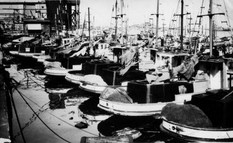
(ca. 1920s)* – View of fishing boats anchored in L.A. Harbor.
Port of Los Angeles in 1913. Source: http://waterandpower.org/museum/Early_Views_of_San_Pedro_and_Wilmington.html LA Public Library photo
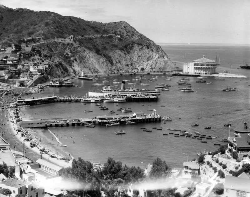
1920’s View of Avalon Bay across Crescent Bay, on Santa Catalina Island as seen from a mountain top. The Catalina Casino, surrounded by the sea on three sides, is visible at the edge of the bay on the right along with several boats along with the S.S. Catalina, “The Great White Steamer”.Port of Los Angeles in 1913. Source: http://waterandpower.org/museum/Early_Views_of_San_Pedro_and_Wilmington.html LA Public Library photo
Korean Bell:
The Korean Bell of Friendship is a massive bronze bell housed in a stone pavilion in Angel’s Gate Park, in the San Pedro district of Los Angeles, California. Located at the corner of Gaffey and 37th Streets, the section of the park is alternatively called the “Korean-American Peace Park,” and occupies part of the former Upper Reservation of Fort MacArthur.
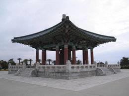
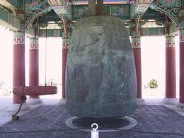
Korean Friendship Bell Close up view of Korean Friendship Bell
The bell was donated by the Republic of Korea to the people of Los Angeles, California to celebrate the bicentennial of the United States, to honor American veterans of the Korean War, and to symbolize friendship between the two nations. . It was dedicated on October 3, 1976 and declared Los Angeles Historic-Cultural Monument No. 187 in 1978.
Schools:
Students in San Pedro attend schools of the Los Angeles Unified School District. In 1983 the unincorporated area of Eastview , adjacent to San Pedro, was annexed to the City of Rancho Palos Verdes, but there were no changes made to school district boundaries and Eastview remained in the Los Angeles Unified School District. During the years 1983, through at least 1995, the LAUSD opposed all attempts of the PVPUSD to revise its District boundaries to include Eastview. In 1991 the entire Board of Education for PVPUSD signed Resolution 16 supporting the territory transfer for the Eastview area from LAUSD to PVPUSD. PVPUSD was successful in using the school district reorganization process that included an election where 84% of the Eastview residents approved the transfer. However, the process failed when the courts determined that the election was invalid since it did not include residents of the LAUSD. Ultimately,SB 1681 made Eastview an optional attendance area in 1999.
Those students who live in the Eastview area ( Area 88 in the boundary matrix at Attendance Boundaries) have a one-time election to enroll in either the Palos Verdes School District ( attending Dapplygray Elementary and Miraleste Intermediate ) , or the Los Angeles Unified School District ( Dodson Middle School and Crestwood Elementary School. ). Those living in the Eastview area do not pay the bonded indebtedness on their property tax bills ( 2009/2010 of $21.64 per $100,000 valuation ) for the Palos Verdes School District, but instead are billed for the Los Angeles Unified School District bonded indebtedness on their property tax bills (2009/2010 of $151 per $100,000 valuation ). Eastview residents vote only on School Board elections for Los Angeles Unified Schools regardless of whether they have elected to attend the Palos Verdes School District.
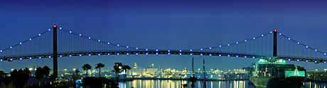
The Vincent Thomas Bridge is a 1,500-foot long suspension bridge crossing the Los Angeles Harbor linking San Pedro, California with terminal island.
The Vincent Thomas Bridge
When the bridge opened in 1963, the toll was 25 cents in each direction. In 1983, the toll increased to 50 cents for westbound traffic but became free for eastbound traffic. In 2000, toll was removed. Prior to the bridge’s construction, the Terminal Island Ferry transported people and cars to Terminal Island. The bridge is named after California AssemblymanVincent Thomas of San Pedro.
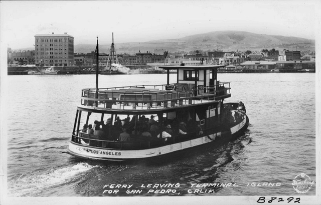
Terminal Island Ferry
Sources:
“Palos Verdes Peninsula, Time and the Terraced Land”, by Augusta Fink
Information on the San Pedro Korean Bell:
http://en.wikipedia.org/wiki/Korean_Bell_of_Friendship
Information on Drum Barracks in San Pedro:
http://www.militarymuseum.org/DrumBks.html
Information on the Japanese in San Pedro
http://www.cr.nps.gov/history/online_books/5views/5views4h101.htm
http://waterandpower.org/museum/California_Historical_Landmarks_Listing_LA_Page_1.html
Click on the following links for the history of individual cities in the South Bay Los Angeles beach communities:
HISTORY OF PALOS VERDES ESTATES
HISTORY OF RANCHO PALOS VERDES