The following include excerpts of two article published in the Daily Breeze on 8/4/08 by Stephanie Walton, Staff writer:
Palos Verdes Fault
A Southern California Earthquake Data Center map of fault lines in the Los Angeles region shows two faults – one with two branches – that run through or near the South Bay.
The two faults running through the South Bay are the Palos Verdes and the Newport-Inglewood faults.
The Palos Verdes Fault Zone, which traverses the southern portion of the South Bay, has two branches – the Cabrillo Fault and the Redondo Canyon Fault – which join the main fault at different points along its route.
The SCEDC map shows the Redondo Canyon Fault joining the Palos Verdes Fault offshore and extending west into Santa Monica Bay.
The map shows the Cabrillo Fault joining the Palos Verdes Fault offshore, just outside San Pedro Bay, and continuing northwest through San Pedro and into the communities of the Palos Verdes Peninsula.
The SCEDC Web
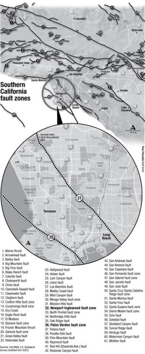
(Paul Penzella/Staff Illustrator)
site notes that the roughly 50-mile-long fault line continues southward, offshore, as the Palos Verdes-Coronado Bank Fault Zone.
The exact land route of the Palos Verdes Fault has been erased by years of paved streets, housing developments and land modifications, said Tom Henyey, director of the Southern California Earthquake Center at USC.
“It’s unfortunate we don’t know the location more precisely,” he aid. “Man has pretty well wiped out the evidence.”
The fault line that extends into the Pacific Ocean makes shore somewhere near the southwest point of the Redondo Beach-Torrance border, curves around the base of the Palos Verdes Peninsula roughly midway between Pacific Coast Highway and the Peninsula. It continues this southerly course until it eventually runs into the Los Angeles Harbor, Henyey said.
SCEC scientists have a better picture of the fault ‘s course in the harbor after mapping the strike-slip fault for the Port of Los Angeles’s current expansion project. “We are pretty sure it runs under the Vincent Thomas Bridge,” he said.
A map on the Broadband Seismic Data Collection Center Web site, eqinfo.ucsd.edu/tools (click on interactive map), shows the Newport-Inglewood Fault starting northwest of Kenneth Hahn State Recreation Area and heading southeast. The fault line runs through portions of Culver City, Baldwin Hills, Inglewood, Athens, Gardena, Harbor Gateway, Rosewood, Carson, Rancho Dominguez, Long Beach and Signal Hill before it traverses into Orange County. That earthquake fault travels from Newport Beach in a northwest line through Signal Hill, Dominguez Hills and Baldwin Hills before terminating somewhere in the vicinity of Beverly Hills, Henyey said.
The Newport-Inglewood Fault, the Web site says, “can easily be noted there by the existence of a chain of low hills extending from Culver City to Signal Hill.
The most recent major rupture on this fault line is the 1933 Long Beach earthquake, the Web site says.