PALOS VERDES ROAD DEVELOPMENT
Road Construction on the Palos Verdes Peninsula did not take place until the 1920’s. Palos Verdes Drive West in the Valmonte and Malaga Cove area was the first road developed as part of the original Palos Verdes Project. Palos Verdes Drive East in the Miraleste area, then known as Western Ave. and which was then part of the Palos Verdes Project, was then developed to facilitate lot sales there.
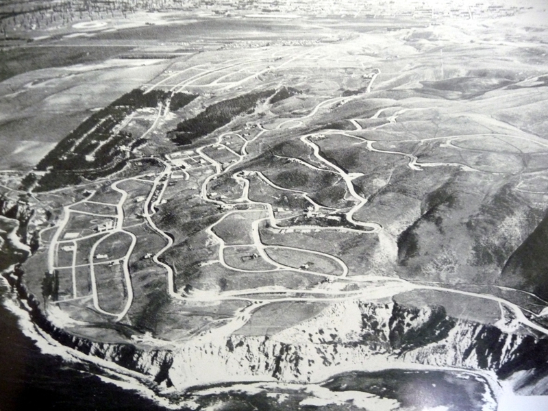
Above is an early 1920’s aerial view of the recently completed roads in Palos Verdes Estates, then known as the Palos Verdes Project.
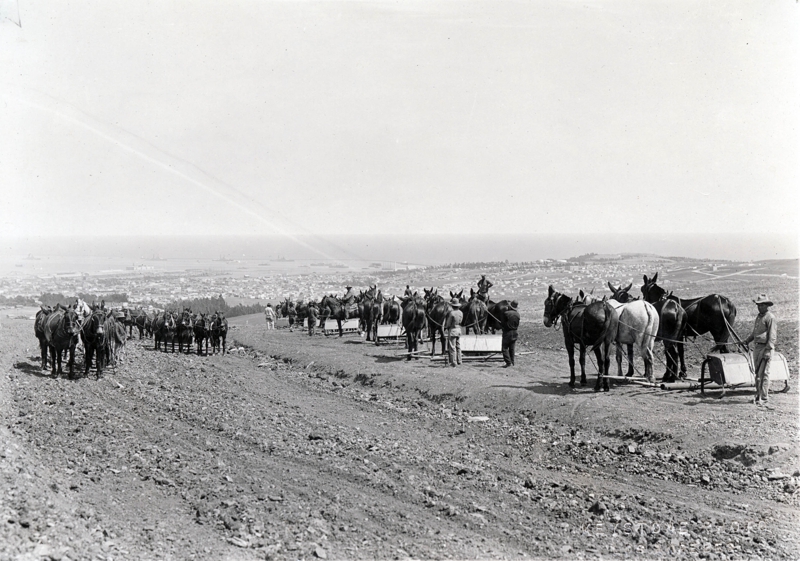
In 1926, the coast road connecting Redondo Beach to San Pedro, previously called Granvia La Costa, now called Palos Verdes Drive West, was completed, including the monumental “Douglas Cut”, which was blasted away above Bluff Cove. This road was simply referred to as the Coast Road.

Douglas Cut (Picture Courtesy of Palos Verdes Peninsula Library District)
 Construction of Palos Verdes Coast Road at Bluff Cove Douglass Cut
 Road Construction of Palos Verdes Drive West and Yarmouth Road – Site of Lunada Bay Plaza and 1920’s Lunada Bay
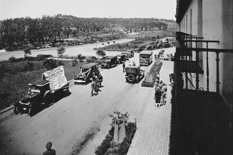
Dedication of Palos Verdes Coast road caravan of cars forming at Malaga Cove Plaza
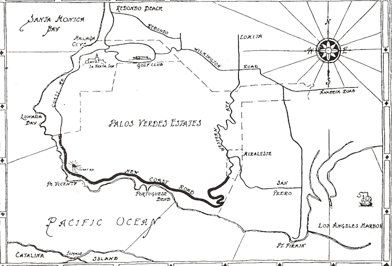
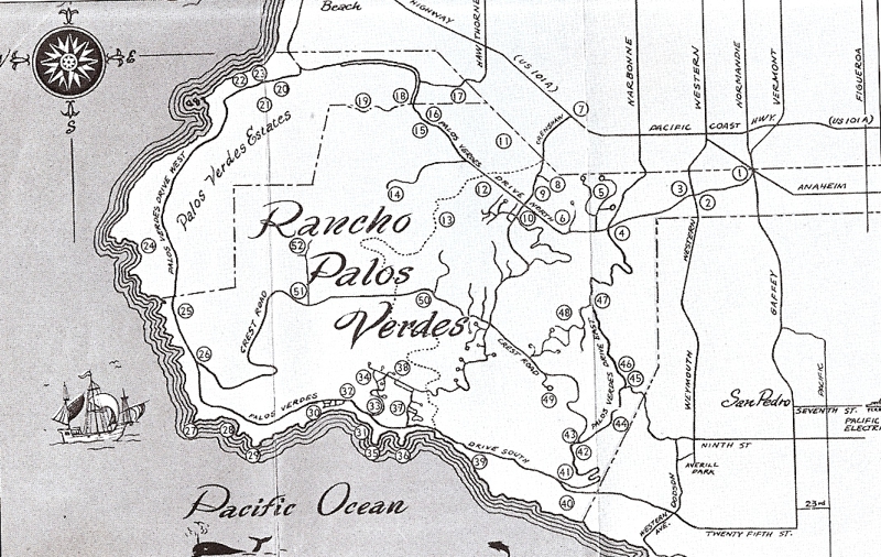
Old map below shows the Coast road connecting to “Western Ave”, which later was renamed Palos Verdes Drive East and now runs into Narbonne Ave on the north. Western Avenue later was constructed to run parallel to and between Narbonne/Palos Verdes Drive East and Gaffey Street in San Pedro.
Pacific Coast Highway was named Redondo and Wilmington Road at that time and connected to Anaheim Street at the current junction with Western Ave. Palos Verdes Drive North was completed in the mid 1930’s.
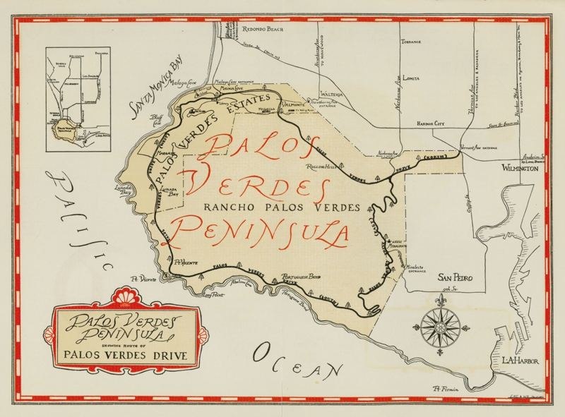 1930’s map showing the recently completed Palos Verdes Drive North and renaming Western Ave. to Palos Verdes Drive East . Note that Pacific Coast Highway at that time was known as “State St. (Highway 101)”.
The extension of Crenshaw from Crest road to Palos Verdes Drive South was never completed due to the Portuguese Bend landslide in the mid 1950’s which was triggered by road grading for the extension of Crenshaw Blvd.
 1949 Roadmap showing planned extension of Crenshaw ( dotted line ) from Torrance to Palos Verdes Drive south, Hawthorne Blvd. ending in Torrance , and Crest Road extending down to Palos Verdes Dr. West/South . Crenshaw used to terminate at the entrance to Rolling Hills, and when extended into Rolling hills to Crest road, the old portion of Crenshaw going into Rolling Hills was renamed Rolling Hills Road. Also notice the new Western Ave. which had not yet been extended into San Pedro.
Early road construction on Palos Verdes Peninsula. May be construction of Crest Road ( Note port of Los Angeles in background )
Road construction moved forward rapidly in the late 1950’s and through the mid 1960’s..Construction of Crenshaw Boulevard up a canyon from Palos Verdes Drive North to Silver Spur road commenced in mid June 1950. and was completed in September 1951. Crest road, constructed by the developers of the Palos Verdes Project, ran from Palos Verdes Dr. East across the top of the hill and then down to Palos Verdes Drive West along the current lower portion of Hawthorne Blvd. Prior to extending Crenshaw up the hill, Crenshaw had extended to the gated entrance to Rolling Hills, and that portion of Crenshaw was then renamed Rolling Hills Road.
Labor for the construction of Crenshaw included that of inmates at County Detention Camp No. 7 in the Palos Verdes Hills. An article in the Torrance Press on the opening day of Crenshaw Blvd. on September 20, 1951 had the following quotes:
“Dedicating the road, Supervisor ( Raymond V. ) Darby said that its construction was made possible through use of men quartered at County Detention Camp Number 7, located In the Palos Verdes Hills.. “Thus,” Darby said, “we have been able to effect a constructive road project and alleviate the County jail of over-crowding. We have been able to build a key link in a badly-needed north/south highway that will be of great benefit to Torrance, Lomita and other areas in the southeastern section of the County.”The road opened today is comprised of Montemalaga Drive, Silver Spur Road, Crenshaw boulevard and Crest Road. It will provide a public cross-peninsula highway until Crenshaw is completed in its entirety. The road originates on Palos Verdes Drive North, half a mile east of the Palos Verdes Estates boundary, and terminates on Palos Verdes Drive West, half a mile west of Point Vicente Lighthouse. The Montemalaga ‘and Silver Spur sections originally were constructed by the County as an access road to Detention Camp No. 7. Crest Road was built by the Palos Verdes Corporation and today Frank A. Vanderlip, Jr., corporation president, presented 4.2 miles of Crest Road, lying between its intersection with Crenshaw and Palos Verdes Drive West, to the County so the Public would immediately have a cross-peninsula thoroughfare.”
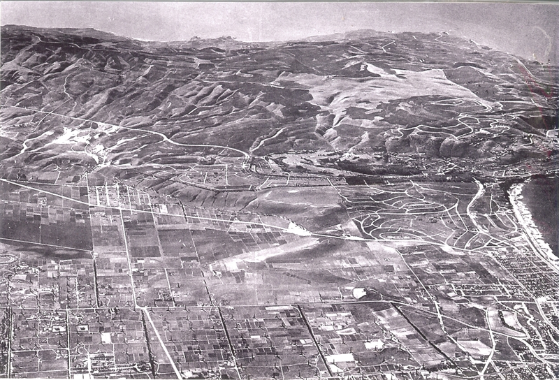
Above is an early aerial view, probably in the mid 1930’s, of South Torrance and the Palos Verdes Peninsula. Note that Hawthorne Blvd had not been extended into the Peninsula, and Crenshaw had also not yet been constructed. The light area in the upper left of the picture is the former Palos Verdes Landfill site which was then being mined for dicalite. Pacific Coast Hwy runs left to right in the middle of the picture, and above that is the recently constructed Palos Verdes Drive North. The Hollywood Riviera project is in the far right center of the picture.
The extension of Crenshaw from Crest road to Palos Verdes Drive South was never completed due to the Portuguese Bend landslide in the mid 1950’s which was triggered by road grading for the extension of Crenshaw Blvd.
Construction of Hawthorne Blvd. through the Peninsula was completed in several segments. Hawthorne Blvd. was completed from Silver Spur Road to Crest in 1959. The segment from Palos Verdes Drive North to Silver Spur Road was completed in 1961. Hawthorne Avenue veered right into Palos Verdes Estates at what is today called Via Valmonte. After several years of planning, the final segment extending Hawthorne Blvd. from Newton in Torrance to Palos Verdes Drive North was completed in 1965.
For more information on the history of the South Bay and the Palos Verdes Peninsula, go to http://www.southbayhistory.com a page on my website https://www.maureenmegowan.com
.
For more information about Palos Verdes and South Bay Real Estate and buying and selling a home on the Palos Verdes Peninsula, visit my website at https://www.maureenmegowan.com . I try to make this the best real estate web blog in the South Bay Los Angeles and the Palos Verdes Peninsula. I would love to hear your comments or suggestions.